
Faire un don
Équipez-vous pour votre prochaine aventure :
En tant que Partenaire Amazon, ce site perçoit une commission sur les achats éligibles sans surcoût pour vous.
Carte topographique Apple Valley
Cliquez sur la carte pour afficher l’altitude.
Faire un don
Équipez-vous pour votre prochaine aventure :
En tant que Partenaire Amazon, ce site perçoit une commission sur les achats éligibles sans surcoût pour vous.
Apple Valley
According to the United States Census Bureau, the city has a total area of 17.57 square miles (45.51 km2), of which 16.86 square miles (43.67 km2) is land and 0.71 square miles (1.84 km2) is water. The city's geography is rolling, with elevation from the lowest to the highest points in the city varying by one hundred feet (thirty metres) or more. The downtown area and its adjacent residential district (which formed the original core of the city when it was incorporated) are in a shallow valley.
Faire un don
Équipez-vous pour votre prochaine aventure :
En tant que Partenaire Amazon, ce site perçoit une commission sur les achats éligibles sans surcoût pour vous.
À propos de cette carte
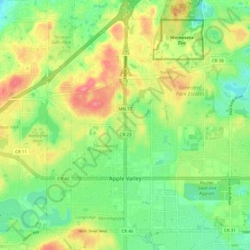
Nom : Carte topographique Apple Valley, altitude, relief.
Lieu : Apple Valley, Dakota County, Minnesota, 55124, United States (44.71734 -93.24835 44.77589 -93.15134)
Altitude moyenne : 301 m
Altitude minimum : 270 m
Altitude maximum : 343 m
Faire un don
Équipez-vous pour votre prochaine aventure :
En tant que Partenaire Amazon, ce site perçoit une commission sur les achats éligibles sans surcoût pour vous.
Autres cartes topographiques
Cliquez sur une carte pour visualiser sa topographie, son altitude et son relief.
Burnsville
United States > Minnesota > Dakota County > Burnsville > Burnsville
Altitude moyenne : 275 m
Faire un don
Équipez-vous pour votre prochaine aventure :
En tant que Partenaire Amazon, ce site perçoit une commission sur les achats éligibles sans surcoût pour vous.
Farmington
United States > Minnesota > Dakota County > Farmington > Farmington
Altitude moyenne : 280 m
Faire un don
Équipez-vous pour votre prochaine aventure :
En tant que Partenaire Amazon, ce site perçoit une commission sur les achats éligibles sans surcoût pour vous.