
Faire un don
Équipez-vous pour votre prochaine aventure :
En tant que Partenaire Amazon, ce site perçoit une commission sur les achats éligibles sans surcoût pour vous.
Carte topographique Windmill Farm
Cliquez sur la carte pour afficher l’altitude.
Faire un don
Équipez-vous pour votre prochaine aventure :
En tant que Partenaire Amazon, ce site perçoit une commission sur les achats éligibles sans surcoût pour vous.
À propos de cette carte
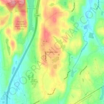
Nom : Carte topographique Windmill Farm, altitude, relief.
Altitude moyenne : 162 m
Altitude minimum : 111 m
Altitude maximum : 228 m
Faire un don
Équipez-vous pour votre prochaine aventure :
En tant que Partenaire Amazon, ce site perçoit une commission sur les achats éligibles sans surcoût pour vous.
Autres cartes topographiques
Cliquez sur une carte pour visualiser sa topographie, son altitude et son relief.
Armonk
United States > New York > Westchester County > Armonk
Situated 11 miles from the coast in the southeastern corner of New York, Armonk shares a border with Connecticut. The landscape is hilly and forested, with a mean elevation of 387 feet, and is home to the highest point in Westchester County with an elevation of 1,396 feet.
Altitude moyenne : 156 m
Armonk
United States > New York > Westchester County > Armonk
Situated 11 miles from the coast in the southeastern corner of New York, Armonk shares a border with Connecticut. The landscape is hilly and forested with a mean elevation of 387 feet.
Altitude moyenne : 155 m
Armonk
United States > New York > Westchester County > Armonk
Situated 11 miles from the coast in the southeastern corner of New York, Armonk shares a border with Connecticut. The landscape is hilly and forested with a mean elevation of 387 feet.
Altitude moyenne : 155 m