
Faire un don
Équipez-vous pour votre prochaine aventure :
En tant que Partenaire Amazon, ce site perçoit une commission sur les achats éligibles sans surcoût pour vous.
Carte topographique Leavenworth
Cliquez sur la carte pour afficher l’altitude.
Faire un don
Équipez-vous pour votre prochaine aventure :
En tant que Partenaire Amazon, ce site perçoit une commission sur les achats éligibles sans surcoût pour vous.
Leavenworth
Leavenworth is located at 39°18′40″N 94°55′21″W / 39.31111°N 94.92250°W / 39.31111; -94.92250 (39.3111112, −94.9224637) at an elevation of 840 feet (256 m).[5] Located in northeastern Kansas at the junction of U.S. Route 73 and Kansas Highway 92 (K-92), Leavenworth is 25 mi (40 km) northwest of downtown Kansas City, 145 mi (233 km) south-southeast of Omaha, and 165 mi (266 km) northeast of Wichita.[18][19]
Faire un don
Équipez-vous pour votre prochaine aventure :
En tant que Partenaire Amazon, ce site perçoit une commission sur les achats éligibles sans surcoût pour vous.
À propos de cette carte
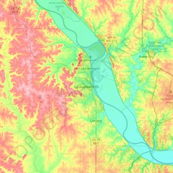
Nom : Carte topographique Leavenworth, altitude, relief.
Altitude moyenne : 277 m
Altitude minimum : 223 m
Altitude maximum : 347 m
Faire un don
Équipez-vous pour votre prochaine aventure :
En tant que Partenaire Amazon, ce site perçoit une commission sur les achats éligibles sans surcoût pour vous.