
Carte topographique Baltimore
Carte interactive
Cliquez sur la carte pour afficher l’altitude.
À propos de cette carte
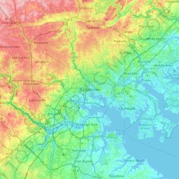
Nom : Carte topographique Baltimore, altitude, relief.
Lieu : Baltimore, Maryland, 21233, United States (39.13088 -76.77076 39.45088 -76.45076)
Altitude moyenne : 65 m
Altitude minimum : -5 m
Altitude maximum : 219 m
Baltimore is in north-central Maryland on the Patapsco River close to where it empties into the Chesapeake Bay. The city is also located on the fall line between the Piedmont Plateau and the Atlantic coastal plain, which divides Baltimore into "lower city" and "upper city". The city's elevation ranges from sea level at the harbor to 480 feet (150 m) in the northwest corner near Pimlico.
Autres cartes topographiques
Cliquez sur une carte pour visualiser sa topographie, son altitude et son relief.
Middle East
United States > Maryland > Baltimore
Middle East, Baltimore, Maryland, United States
Altitude moyenne : 29 m
Cedarcroft
United States > Maryland > Baltimore
Cedarcroft, Baltimore, Maryland, United States
Altitude moyenne : 126 m
Broadway East
United States > Maryland > Baltimore
Broadway East, Baltimore, Maryland, United States
Altitude moyenne : 36 m
Woodberry
United States > Maryland > Baltimore
Woodberry, Baltimore, Maryland, United States
Altitude moyenne : 94 m
Saint Josephs
United States > Maryland > Baltimore
Saint Josephs, Baltimore, Maryland, United States
Altitude moyenne : 49 m
Frankford
United States > Maryland > Baltimore
Frankford, Baltimore, Maryland, 21206, United States
Altitude moyenne : 40 m