Géolocaliser
👉 Easily get elevation data in JSON, GeoTIFF and KML formats using Elevation API
Merci de soutenir ce site ❤️
Faire un don

Carte topographique Tarn Hows

Cliquez sur la carte pour afficher l’altitude.

👉 Easily get elevation data in JSON, GeoTIFF and KML formats using Elevation API
Merci de soutenir ce site ❤️
Faire un don

À propos de cette carte

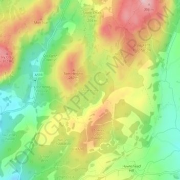
Nom : Carte topographique Tarn Hows, altitude, relief.

Lieu : Tarn Hows, Coniston, Westmorland and Furness, England, United Kingdom (54.38820 -3.03773 54.39516 -3.02888)

Altitude moyenne : 187 m

Altitude minimum : 74 m

Altitude maximum : 315 m

Autres cartes topographiques

Cliquez sur une carte pour visualiser sa topographie, son altitude et son relief.

Old Man of Coniston

United Kingdom > England > Westmorland and Furness > Coniston

The first section rising steeply from Coniston is a metalled road, maintained partly to provide access to the quarry. This leads to a car park at an altitude of 740 ft (230 m), a popular starting point for climbs. Beyond here motor vehicles are prohibited, but the track continues to its summit at 2,000 ft (610…

Altitude moyenne : 501 m

Équipez-vous pour votre prochaine aventure :

🔦Lampes torches LED - Lampes puissantes pour activités nocturnes
Cafetières Nomades - Un bon café après une ascension difficile
📟Altimètres Barométriques - Suivez votre dénivelé positif et les changements météo en temps réel
🔋Adaptateurs de Prise - Pour les touristes explorant la Belgique
🧣Tours de Cou Buff - Polyvalence et chaleur pour toutes les saisons

En tant que Partenaire Amazon, ce site perçoit une commission sur les achats éligibles sans surcoût pour vous.