
Carte topographique Hünibach
Carte interactive
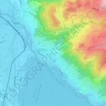
Cliquez sur la carte pour afficher l’altitude.
À propos de cette carte
Nom : Carte topographique Hünibach, altitude, relief.
Altitude moyenne : 689 m
Altitude minimum : 554 m
Altitude maximum : 1.124 m
Autres cartes topographiques
Cliquez sur une carte pour visualiser sa topographie, son altitude et son relief.
Merligen
Switzerland > Bern > Thun administrative district
Merligen, Sigriswil, Horrenbach-Buchen, Thun administrative district, Oberland administrative region, Bern, 3658, Switzerland
Altitude moyenne : 767 m
Thun
Switzerland > Bern > Thun administrative district
Thun, Thun administrative district, Oberland administrative region, Bern, Switzerland
Altitude moyenne : 637 m
Oberstocken
Switzerland > Bern > Thun administrative district > Stocken-Höfen
Oberstocken, Stocken-Höfen, Thun administrative district, Oberland administrative region, Bern, 3632, Switzerland
Altitude moyenne : 1.100 m