
Carte topographique Lachen
Carte interactive
Cliquez sur la carte pour afficher l’altitude.
À propos de cette carte
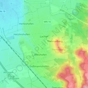
Nom : Carte topographique Lachen, altitude, relief.
Altitude moyenne : 653 m
Altitude minimum : 607 m
Altitude maximum : 761 m
Autres cartes topographiques
Cliquez sur une carte pour visualiser sa topographie, son altitude et son relief.
Erisried
Deutschland > Bayern > Landkreis Unterallgäu
Erisried, Stetten, Dirlewang, Landkreis Unterallgäu, Bayern, 87778, Deutschland
Altitude moyenne : 650 m
Markt Rettenbach
Deutschland > Bayern > Landkreis Unterallgäu
Markt Rettenbach, Landkreis Unterallgäu, Bayern, 87733, Deutschland
Altitude moyenne : 702 m