
Faire un don
Équipez-vous pour votre prochaine aventure :
En tant que Partenaire Amazon, ce site perçoit une commission sur les achats éligibles sans surcoût pour vous.
Carte topographique Diamond Lake
Cliquez sur la carte pour afficher l’altitude.
Faire un don
Équipez-vous pour votre prochaine aventure :
En tant que Partenaire Amazon, ce site perçoit une commission sur les achats éligibles sans surcoût pour vous.
À propos de cette carte
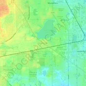
Nom : Carte topographique Diamond Lake, altitude, relief.
Lieu : Diamond Lake, Lake County, Illinois, 60060, United States (42.22447 -88.03008 42.26447 -87.99008)
Altitude moyenne : 230 m
Altitude minimum : 214 m
Altitude maximum : 252 m
Faire un don
Équipez-vous pour votre prochaine aventure :
En tant que Partenaire Amazon, ce site perçoit une commission sur les achats éligibles sans surcoût pour vous.
Autres cartes topographiques
Cliquez sur une carte pour visualiser sa topographie, son altitude et son relief.
Faire un don
Équipez-vous pour votre prochaine aventure :
En tant que Partenaire Amazon, ce site perçoit une commission sur les achats éligibles sans surcoût pour vous.
Waukegan
United States > Illinois > Lake County
Waukegan is on the shore of Lake Michigan, about 11 miles (18 km) south of the border with Wisconsin and 37 miles (60 km) north of downtown Chicago at an elevation around 650 feet (200 m) above sea level. Chicago has two major streets that venture north to Waukegan, one being Sheridan Road, which extends north…
Altitude moyenne : 194 m
Highland Park
United States > Illinois > Lake County
In 1867, ten men purchased Highland Park for $39,198.70. They were the original stockholders of the Highland Park Building Company. Following construction of the Chicago and Milwaukee Railroad, a depot was established at Highland Park and a plat, extending south to Central Avenue, was laid out in 1856. At that…
Altitude moyenne : 194 m
Faire un don
Équipez-vous pour votre prochaine aventure :
En tant que Partenaire Amazon, ce site perçoit une commission sur les achats éligibles sans surcoût pour vous.
Faire un don
Équipez-vous pour votre prochaine aventure :
En tant que Partenaire Amazon, ce site perçoit une commission sur les achats éligibles sans surcoût pour vous.
Mundelein
United States > Illinois > Lake County
Mundelein is located 33 miles (53 km) northwest of the Chicago Loop. The area of the village is 10.12 square miles (26.2 km2), 0.45 square miles (1.2 km2) of which is water. The elevation of the village is 742 feet (226 m). Mundelein borders Hawthorn Woods and Vernon Hills to the south and east, and is…
Altitude moyenne : 231 m
Faire un don
Équipez-vous pour votre prochaine aventure :
En tant que Partenaire Amazon, ce site perçoit une commission sur les achats éligibles sans surcoût pour vous.
Faire un don
Équipez-vous pour votre prochaine aventure :
En tant que Partenaire Amazon, ce site perçoit une commission sur les achats éligibles sans surcoût pour vous.
Highland Park
United States > Illinois > Lake County
In 1867, ten men purchased Highland Park for $39,198.70. They were the original stockholders of the Highland Park Building Company. Following construction of the Chicago and Milwaukee Railroad, a depot was established at Highland Park and a plat, extending south to Central Avenue, was laid out in 1856. At that…
Altitude moyenne : 193 m
Faire un don
Équipez-vous pour votre prochaine aventure :
En tant que Partenaire Amazon, ce site perçoit une commission sur les achats éligibles sans surcoût pour vous.
Waukegan
United States > Illinois > Lake County
Waukegan is located at 42°22′13″N 87°52′16″W / 42.37028°N 87.87111°W / 42.37028; -87.87111 (42.3703140, −87.8711404). Waukegan is on the shore of Lake Michigan, about 11 miles (18 km) south of the border with Wisconsin and 37 miles (60 km) north of downtown Chicago at an elevation around…
Altitude moyenne : 197 m
Faire un don
Équipez-vous pour votre prochaine aventure :
En tant que Partenaire Amazon, ce site perçoit une commission sur les achats éligibles sans surcoût pour vous.
Mundelein
United States > Illinois > Lake County
Mundelein is located 33 miles (53 km) northwest of the Chicago Loop. The area of the village is 10.12 square miles (26.2 km2), 0.45 square miles (1.2 km2) of which is water. The elevation of the village is 742 feet (226 m). Mundelein borders Hawthorn Woods and Vernon Hills to the south and east, and is…
Altitude moyenne : 231 m
Faire un don
Équipez-vous pour votre prochaine aventure :
En tant que Partenaire Amazon, ce site perçoit une commission sur les achats éligibles sans surcoût pour vous.
Highland Park
United States > Illinois > Lake County
In 1867, ten men purchased Highland Park for $39,198.70. They were the original stockholders of the Highland Park Building Company. Following construction of the Chicago and Milwaukee Railroad, a depot was established at Highland Park and a plat, extending south to Central Avenue, was laid out in 1856. At that…
Altitude moyenne : 193 m
Faire un don
Équipez-vous pour votre prochaine aventure :
En tant que Partenaire Amazon, ce site perçoit une commission sur les achats éligibles sans surcoût pour vous.
Faire un don
Équipez-vous pour votre prochaine aventure :
En tant que Partenaire Amazon, ce site perçoit une commission sur les achats éligibles sans surcoût pour vous.
Faire un don
Équipez-vous pour votre prochaine aventure :
En tant que Partenaire Amazon, ce site perçoit une commission sur les achats éligibles sans surcoût pour vous.
Highwood
United States > Illinois > Lake County
Highwood is located in southeastern Lake County at 42°12′19″N 87°48′44″W / 42.205357°N 87.812345°W / 42.205357; -87.812345, on a ridge 100 feet (30 m) above the elevation of Lake Michigan.
Altitude moyenne : 198 m
Lake Zurich
United States > Illinois > Lake County
Lake Zurich is located at 42°11′32″N 88°5′17″W / 42.19222°N 88.08806°W / 42.19222; -88.08806 (42.192324, -88.088098), with an elevation of 850 feet (260 m) above sea level.
Altitude moyenne : 259 m
Faire un don
Équipez-vous pour votre prochaine aventure :
En tant que Partenaire Amazon, ce site perçoit une commission sur les achats éligibles sans surcoût pour vous.
Highland Park
United States > Illinois > Lake County
In 1867, ten men purchased Highland Park for $39,198.70. They were the original stockholders of the Highland Park Building Company. Following construction of the Chicago and Milwaukee Railroad, a depot was established at Highland Park and a plat, extending south to Central Avenue, was laid out in 1856. At that…
Altitude moyenne : 194 m
Faire un don
Équipez-vous pour votre prochaine aventure :
En tant que Partenaire Amazon, ce site perçoit une commission sur les achats éligibles sans surcoût pour vous.
Faire un don
Équipez-vous pour votre prochaine aventure :
En tant que Partenaire Amazon, ce site perçoit une commission sur les achats éligibles sans surcoût pour vous.
Faire un don
Équipez-vous pour votre prochaine aventure :
En tant que Partenaire Amazon, ce site perçoit une commission sur les achats éligibles sans surcoût pour vous.
Highland Park
United States > Illinois > Lake County
In 1867, ten men purchased Highland Park for $39,198.70. They were the original stockholders of the Highland Park Building Company. Following construction of the Chicago and Milwaukee Railroad, a depot was established at Highland Park and a plat, extending south to Central Avenue, was laid out in 1856. At that…
Altitude moyenne : 194 m
Faire un don
Équipez-vous pour votre prochaine aventure :
En tant que Partenaire Amazon, ce site perçoit une commission sur les achats éligibles sans surcoût pour vous.
Faire un don
Équipez-vous pour votre prochaine aventure :
En tant que Partenaire Amazon, ce site perçoit une commission sur les achats éligibles sans surcoût pour vous.