
Faire un don
Équipez-vous pour votre prochaine aventure :
En tant que Partenaire Amazon, ce site perçoit une commission sur les achats éligibles sans surcoût pour vous.
Carte topographique Mount Barker
Cliquez sur la carte pour afficher l’altitude.
Faire un don
Équipez-vous pour votre prochaine aventure :
En tant que Partenaire Amazon, ce site perçoit une commission sur les achats éligibles sans surcoût pour vous.
Mount Barker
Mount Barker is located on the plains surrounding the Mount Barker Summit, about 2 km west of the mountain, at 35°04′S 138°51′E / 35.067°S 138.850°E / -35.067; 138.850. Mount Barker is south east of Mount Lofty and Adelaide. It is north of The Coorong, and the west of Murray Bridge. Mount Barker is at an elevation of 360 m.
Faire un don
Équipez-vous pour votre prochaine aventure :
En tant que Partenaire Amazon, ce site perçoit une commission sur les achats éligibles sans surcoût pour vous.
À propos de cette carte
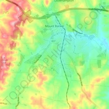
Nom : Carte topographique Mount Barker, altitude, relief.
Altitude moyenne : 368 m
Altitude minimum : 302 m
Altitude maximum : 467 m
Faire un don
Équipez-vous pour votre prochaine aventure :
En tant que Partenaire Amazon, ce site perçoit une commission sur les achats éligibles sans surcoût pour vous.