Géolocaliser
👉 Easily get elevation data in JSON, GeoTIFF and KML formats using Elevation API
Merci de soutenir ce site ❤️
Faire un don

Carte topographique Pulikkanny

Cliquez sur la carte pour afficher l’altitude.

À propos de cette carte

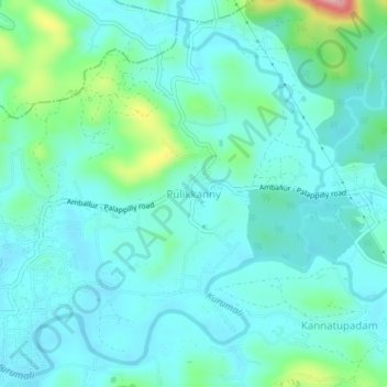
Nom : Carte topographique Pulikkanny, altitude, relief.

Lieu : Pulikkanny, Chalakkudy, Thrissur, Kerala, 680303, India (10.41613 76.34357 10.45613 76.38357)

Altitude moyenne : 36 m

Altitude minimum : 6 m

Altitude maximum : 169 m

Autres cartes topographiques

Cliquez sur une carte pour visualiser sa topographie, son altitude et son relief.

Kuzhur

India > Kerala > Chalakkudy > Valiyaparambu

Altitude moyenne : 7 m

Kakkulissery

India > Kerala > Chalakkudy > Valiyaparambu

Altitude moyenne : 10 m

Thiruthiparambu East

India > Kerala > Chalakkudy > Chalakudy

Altitude moyenne : 10 m

Athirappilly

India > Kerala > Chalakkudy

Altitude moyenne : 406 m

Kadukutty

India > Kerala > Chalakkudy > Sampaloor

Altitude moyenne : 8 m

Nandipulam

India > Kerala > Chalakkudy

Altitude moyenne : 16 m

St James Hospital

India > Kerala > Chalakkudy > Chalakudy

Altitude moyenne : 14 m

Lower Sholayar Dam

India > Kerala > Chalakkudy

Altitude moyenne : 773 m

St James Hospital

India > Kerala > Chalakkudy > Chalakudy

Altitude moyenne : 14 m

Mattathur

India > Kerala > Chalakkudy > Kodaly

Altitude moyenne : 199 m

Équipez-vous pour votre prochaine aventure :

📸Trépieds de Voyage - Stabilité pour vos photos de paysages panoramiques
🧴Protections Solaires - Indispensable lors des longues expositions en altitude
📱Supports smartphone vélo - Supports pour navigation GPS
🌂Parapluies Tempête - Robustesse testée pour le climat belge
🪓Couteaux outdoor - Couteaux polyvalents pour randonnée

En tant que Partenaire Amazon, ce site perçoit une commission sur les achats éligibles sans surcoût pour vous.