
Faire un don
Équipez-vous pour votre prochaine aventure :
En tant que Partenaire Amazon, ce site perçoit une commission sur les achats éligibles sans surcoût pour vous.
Carte topographique Tres Piedras
Cliquez sur la carte pour afficher l’altitude.
Faire un don
Équipez-vous pour votre prochaine aventure :
En tant que Partenaire Amazon, ce site perçoit une commission sur les achats éligibles sans surcoût pour vous.
Tres Piedras
Tres Piedras is located approximately 30 miles northwest of Taos, and west of the Rio Grande on U.S. Route 64. At approximately 8,000 feet (2,400 m) in altitude, it is located within the southern portion of the San Juan Range of the Rocky Mountains. Tres Piedras is on the western edge of a sagebrush plain, with ponderosa pines growing throughout the village. The village is adjacent to the Carson National Forest. The ZIP Code for Tres Piedras is 87577.
Faire un don
Équipez-vous pour votre prochaine aventure :
En tant que Partenaire Amazon, ce site perçoit une commission sur les achats éligibles sans surcoût pour vous.
À propos de cette carte
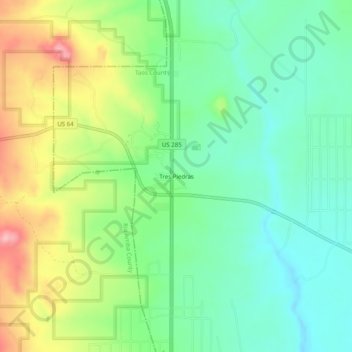
Nom : Carte topographique Tres Piedras, altitude, relief.
Altitude moyenne : 2.476 m
Altitude minimum : 2.423 m
Altitude maximum : 2.572 m
Faire un don
Équipez-vous pour votre prochaine aventure :
En tant que Partenaire Amazon, ce site perçoit une commission sur les achats éligibles sans surcoût pour vous.
Autres cartes topographiques
Cliquez sur une carte pour visualiser sa topographie, son altitude et son relief.
Taos
United States > New Mexico > Taos County
The elevation of the town is 6,969 feet (2,124 m). Just north of Taos is Wheeler Peak, at 13,161 feet (4,011 m), the highest point in New Mexico. Taos has a warm-summer humid continental climate (Köppen Dfb), though it borders on a semi-arid climate (BSk) due to the low rainfall. The town is characterized by…
Altitude moyenne : 2.180 m
Faire un don
Équipez-vous pour votre prochaine aventure :
En tant que Partenaire Amazon, ce site perçoit une commission sur les achats éligibles sans surcoût pour vous.
Taos Ski Valley
United States > New Mexico > Taos County
Taos Ski Valley is a village and alpine ski resort in the southwestern United States, located in Taos County, New Mexico. The population was 69 at the 2010 census. Until March 19, 2008, it was one of four ski resorts in America to prohibit snowboarding. The Kachina lift, constructed in 2014, serves one of the…
Altitude moyenne : 3.229 m
Faire un don
Équipez-vous pour votre prochaine aventure :
En tant que Partenaire Amazon, ce site perçoit une commission sur les achats éligibles sans surcoût pour vous.
Faire un don
Équipez-vous pour votre prochaine aventure :
En tant que Partenaire Amazon, ce site perçoit une commission sur les achats éligibles sans surcoût pour vous.
Taos Ski Valley
United States > New Mexico > Taos County
Taos Ski Valley is a village and alpine ski resort in the southwestern United States, located in Taos County, New Mexico. The population was 69 at the 2010 census. Until March 19, 2008, it was one of four ski resorts in America to prohibit snowboarding. The Kachina lift, constructed in 2014, serves one of the…
Altitude moyenne : 3.229 m
Faire un don
Équipez-vous pour votre prochaine aventure :
En tant que Partenaire Amazon, ce site perçoit une commission sur les achats éligibles sans surcoût pour vous.
Taos
United States > New Mexico > Taos County
The elevation of the town is 6,969 feet (2,124 m). Just north of Taos is Wheeler Peak, at 13,161 feet (4,011 m), the highest point in New Mexico. Taos has a warm-summer humid continental climate (Köppen Dfb), though it borders on a semi-arid climate (BSk) due to the low rainfall. The town is characterized by…
Altitude moyenne : 2.180 m