Géolocaliser

Carte topographique Lower Millstream

Cliquez sur la carte pour afficher l’altitude.

À propos de cette carte

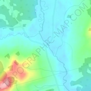
Nom : Carte topographique Lower Millstream, altitude, relief.

Lieu : Lower Millstream, Studholm Parish, Kings County, New Brunswick, E5P 3G8, Canada (45.72570 -65.62542 45.74570 -65.60542)

Altitude moyenne : 40 m

Altitude minimum : 7 m

Altitude maximum : 159 m

Autres cartes topographiques

Cliquez sur une carte pour visualiser sa topographie, son altitude et son relief.

Town of Sussex

Canada > New Brunswick > Kings County

Altitude moyenne : 60 m

Town of Rothesay

Canada > New Brunswick > Kings County

Altitude moyenne : 51 m

Town of Quispamsis

Canada > New Brunswick > Kings County

Altitude moyenne : 53 m

Havelock Parish

Canada > New Brunswick > Kings County

Altitude moyenne : 90 m

Town of Rothesay

Canada > New Brunswick > Kings County

Altitude moyenne : 54 m

Town of Sussex

Canada > New Brunswick > Kings County

Altitude moyenne : 59 m

Équipez-vous pour votre prochaine aventure :

📦Organisateurs de sac - Optimisation du rangement
Montres de Sport GPS - Données topographiques directement au poignet
📡Balises GPS de secours - Sécurité en zones isolées
🥾Chaussures Randonnée Homme - Bottes et chaussures imperméables pour sentiers techniques
🪓Couteaux outdoor - Couteaux polyvalents pour randonnée

En tant que Partenaire Amazon, ce site perçoit une commission sur les achats éligibles sans surcoût pour vous.