
Faire un don
Équipez-vous pour votre prochaine aventure :
En tant que Partenaire Amazon, ce site perçoit une commission sur les achats éligibles sans surcoût pour vous.
Carte topographique Godby
Cliquez sur la carte pour afficher l’altitude.
Faire un don
Équipez-vous pour votre prochaine aventure :
En tant que Partenaire Amazon, ce site perçoit une commission sur les achats éligibles sans surcoût pour vous.
À propos de cette carte
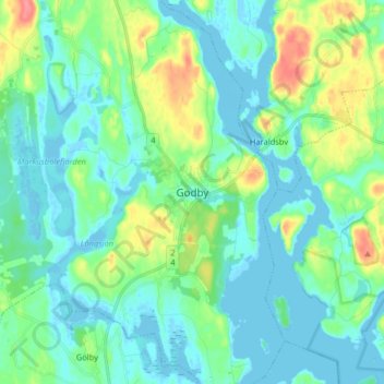
Nom : Carte topographique Godby, altitude, relief.
Altitude moyenne : 15 m
Altitude minimum : -7 m
Altitude maximum : 62 m
Faire un don
Équipez-vous pour votre prochaine aventure :
En tant que Partenaire Amazon, ce site perçoit une commission sur les achats éligibles sans surcoût pour vous.
Autres cartes topographiques
Cliquez sur une carte pour visualiser sa topographie, son altitude et son relief.
Märket
Finland > Åland Islands > Åland Islands > Hammarland
The island consists of mostly smooth diabase rock, with a maximum natural elevation of 2 m (6.6 ft). Most of the area is regularly washed over with seawater in storms, and scoured by drift ice in winter. Plant life, which is limited to low-growing grasses and herbs, persists only in some protected spots.…
Altitude moyenne : 0 m
Faire un don
Équipez-vous pour votre prochaine aventure :
En tant que Partenaire Amazon, ce site perçoit une commission sur les achats éligibles sans surcoût pour vous.