
Faire un don
Équipez-vous pour votre prochaine aventure :
En tant que Partenaire Amazon, ce site perçoit une commission sur les achats éligibles sans surcoût pour vous.
Carte topographique Salisbury
Cliquez sur la carte pour afficher l’altitude.
Faire un don
Équipez-vous pour votre prochaine aventure :
En tant que Partenaire Amazon, ce site perçoit une commission sur les achats éligibles sans surcoût pour vous.
Salisbury
According to the U.S. Census Bureau, the township has a total area of 11.3 square miles (29.2 km2), of which 11.2 square miles (28.9 km2) are land and 0.1 square miles (0.3 km2), or 0.87%, are water.[1] It is drained by the Lehigh River, which separates it from Bethlehem and the east side of Allentown, and borders Upper Saucon Township on South Mountain. Elevations range from approximately 220 feet (67 m) above sea level on the river to 1,030 feet (310 m) in Big Rock County Park.
Faire un don
Équipez-vous pour votre prochaine aventure :
En tant que Partenaire Amazon, ce site perçoit une commission sur les achats éligibles sans surcoût pour vous.
À propos de cette carte
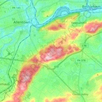
Nom : Carte topographique Salisbury, altitude, relief.
Lieu : Salisbury, Lehigh County, Pennsylvania, United States (40.52913 -75.53005 40.61699 -75.39429)
Altitude moyenne : 143 m
Altitude minimum : 63 m
Altitude maximum : 316 m
Faire un don
Équipez-vous pour votre prochaine aventure :
En tant que Partenaire Amazon, ce site perçoit une commission sur les achats éligibles sans surcoût pour vous.
Autres cartes topographiques
Cliquez sur une carte pour visualiser sa topographie, son altitude et son relief.
East Texas
United States > Pennsylvania > Lehigh County > Lower Macungie Township
Altitude moyenne : 126 m
Fogelsville
United States > Pennsylvania > Lehigh County > Upper Macungie Township
Altitude moyenne : 155 m
North Coplay
United States > Pennsylvania > Lehigh County > Whitehall > Cementon
Altitude moyenne : 116 m
Leather Corner Post
United States > Pennsylvania > Lehigh County > Lowhill Township
Altitude moyenne : 178 m
Faire un don
Équipez-vous pour votre prochaine aventure :
En tant que Partenaire Amazon, ce site perçoit une commission sur les achats éligibles sans surcoût pour vous.
Centreville
United States > Pennsylvania > Lehigh County > Lower Macungie Township
Altitude moyenne : 144 m
Hillside
United States > Pennsylvania > Lehigh County > South Whitehall Township
Altitude moyenne : 152 m
South Mountain
United States > Pennsylvania > Lehigh County > Upper Saucon
Unlike Blue Mountain to its north, South Mountain does not follow a straight geographic line. The mountain ranges in elevation between 500 and 1,300 feet (150 and 400 m) above sea level. The ridge is made of metamorphic rocks and gneiss, which date to the Precambrian era and range from about 570 million to…
Altitude moyenne : 153 m
Faire un don
Équipez-vous pour votre prochaine aventure :
En tant que Partenaire Amazon, ce site perçoit une commission sur les achats éligibles sans surcoût pour vous.
Limeport
United States > Pennsylvania > Lehigh County > Lower Milford Township
Altitude moyenne : 203 m
Orefield
United States > Pennsylvania > Lehigh County > North Whitehall Township
Altitude moyenne : 141 m
Wescosville
United States > Pennsylvania > Lehigh County > Lower Macungie Township
Altitude moyenne : 128 m
Faire un don
Équipez-vous pour votre prochaine aventure :
En tant que Partenaire Amazon, ce site perçoit une commission sur les achats éligibles sans surcoût pour vous.
Fogelsville
United States > Pennsylvania > Lehigh County > Upper Macungie Township
Altitude moyenne : 155 m
Vera Cruz Station
United States > Pennsylvania > Lehigh County > Upper Milford Township
Altitude moyenne : 199 m
South Mountain
United States > Pennsylvania > Lehigh County > Upper Saucon
Unlike Blue Mountain to its north, South Mountain does not follow a straight geographic line. The mountain ranges in elevation between 500 and 1,300 feet (150 and 400 m) above sea level. The ridge is made of metamorphic rocks and gneiss, which date to the Precambrian era and range from about 570 million to…
Altitude moyenne : 153 m
Faire un don
Équipez-vous pour votre prochaine aventure :
En tant que Partenaire Amazon, ce site perçoit une commission sur les achats éligibles sans surcoût pour vous.
Trexlertown
United States > Pennsylvania > Lehigh County > Upper Macungie Township
Trexlertown is located southwest of the center of Lehigh County along the southeastern edge of Upper Macungie Township at an altitude of 397 feet (121 m). It is bordered to the southwest by Breinigsville and to the southeast by Lower Macungie Township. U.S. Route 222 forms the northern edge of the community;…
Altitude moyenne : 127 m
Saegersville
United States > Pennsylvania > Lehigh County > Heidelberg Township
Altitude moyenne : 208 m
North Fogelsville
United States > Pennsylvania > Lehigh County > Upper Macungie Township > Fogelsville
Altitude moyenne : 165 m
Kernsville
United States > Pennsylvania > Lehigh County > North Whitehall Township
Altitude moyenne : 147 m
Faire un don
Équipez-vous pour votre prochaine aventure :
En tant que Partenaire Amazon, ce site perçoit une commission sur les achats éligibles sans surcoût pour vous.
Ironton
United States > Pennsylvania > Lehigh County > North Whitehall Township
Altitude moyenne : 158 m
Leather Corner Post
United States > Pennsylvania > Lehigh County > Lowhill Township
Altitude moyenne : 178 m
Orefield
United States > Pennsylvania > Lehigh County > North Whitehall Township
Altitude moyenne : 141 m
Faire un don
Équipez-vous pour votre prochaine aventure :
En tant que Partenaire Amazon, ce site perçoit une commission sur les achats éligibles sans surcoût pour vous.
Weilersville
United States > Pennsylvania > Lehigh County > Lower Macungie Township
Altitude moyenne : 126 m
Jordan Valley
United States > Pennsylvania > Lehigh County > Heidelberg Township
Altitude moyenne : 213 m
Cherry Hill
United States > Pennsylvania > Lehigh County > Upper Macungie Township
Altitude moyenne : 146 m
Weidasville
United States > Pennsylvania > Lehigh County > Lowhill Township > Weidasville
Altitude moyenne : 170 m
Faire un don
Équipez-vous pour votre prochaine aventure :
En tant que Partenaire Amazon, ce site perçoit une commission sur les achats éligibles sans surcoût pour vous.
Crackersport
United States > Pennsylvania > Lehigh County > South Whitehall Township
Altitude moyenne : 138 m
Ormrod
United States > Pennsylvania > Lehigh County > North Whitehall Township
Altitude moyenne : 148 m