
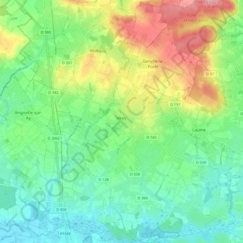
Carte topographique Vesly
Carte interactive
Cliquez sur la carte pour afficher l’altitude.
À propos de cette carte
Nom : Carte topographique Vesly, altitude, relief.
Altitude moyenne : 46 m
Altitude minimum : 2 m
Altitude maximum : 132 m
Autres cartes topographiques
Cliquez sur une carte pour visualiser sa topographie, son altitude et son relief.
50310
France > Normandy > Manche > Saint-Floxel
50310, Saint-Floxel, Cherbourg, Manche, Normandy, Metropolitan France, France
Altitude moyenne : 28 m
Versaille
France > Normandy > Manche > Aumeville-Lestre
Versaille, Aumeville-Lestre, Cherbourg, Manche, Normandy, Metropolitan France, 50630, France
Altitude moyenne : 18 m
Saint-Gilles
Saint-Gilles, Saint-Lô, Manche, Normandy, Metropolitan France, 50180, France
Altitude moyenne : 76 m
Le Mesnil-Tôve
France > Normandy > Manche > Juvigny les Vallées
Le Mesnil-Tôve, Juvigny les Vallées, Avranches, Manche, Normandy, Metropolitan France, 50520, France
Altitude moyenne : 166 m
Sainte-Mère-Église
France > Normandy > Manche > Sainte-Mère-Église
Sainte-Mère-Église, Cherbourg, Manche, Normandy, Metropolitan France, 50480, France
Altitude moyenne : 17 m
Carentan
France > Normandy > Manche > Carentan-les-Marais
Carentan, Carentan-les-Marais, Saint-Lô, Manche, Normandy, Metropolitan France, 50500, France
Altitude moyenne : 9 m
Utah-Beach
France > Normandy > Manche > Sainte-Marie-du-Mont
Utah-Beach, Sainte-Marie-du-Mont, Cherbourg, Manche, Normandy, Metropolitan France, 50480, France
Altitude moyenne : 1 m
La Haye-du-Puits
France > Normandy > Manche > La Haye
La Haye-du-Puits, La Haye, Coutances, Manche, Normandy, Metropolitan France, 50250, France
Altitude moyenne : 53 m
Cherbourg-en-Cotentin
Cherbourg-en-Cotentin, Cherbourg, Manche, Normandy, Metropolitan France, France
Altitude moyenne : 67 m
Château de la Salle
France > Normandy > Manche > Montpinchon > Coquerel
Château de la Salle, D 252, Coquerel, Montpinchon, Coutances, Manche, Normandy, Metropolitan France, 50210, France
Altitude moyenne : 87 m
Le Mont-Saint-Michel
Le Mont-Saint-Michel, Avranches, Manche, Normandy, Metropolitan France, 50170, France
Altitude moyenne : 5 m
Saint-Hilaire-du-Harcouët
Saint-Hilaire-du-Harcouët, Avranches, Manche, Normandy, Metropolitan France, 50600, France
Altitude moyenne : 92 m
Cerisy-la-Salle
France > Normandy > Manche > Cerisy-la-Salle > Cerisy-la-Salle
Cerisy-la-Salle, Coutances, Manche, Normandy, Metropolitan France, 50210, France
Altitude moyenne : 108 m
Camp Patton
France > Normandy > Manche > Néhou > Hameau Gaillot
Camp Patton, Hameau Gaillot, Néhou, Cherbourg, Manche, Normandy, Metropolitan France, 50390, France
Altitude moyenne : 40 m
Varouville
France > Normandy > Manche > Varouville > Varouville
Varouville, Cherbourg, Manche, Normandy, Metropolitan France, 50330, France
Altitude moyenne : 52 m
Saint-Pierre-Langers
France > Normandy > Manche > Saint-Pierre-Langers
Saint-Pierre-Langers, Avranches, Manche, Normandy, Metropolitan France, 50530, France
Altitude moyenne : 68 m
Saint-James
Saint-James, Avranches, Manche, Normandy, Metropolitan France, 50240, France
Altitude moyenne : 104 m
Digosville
France > Normandy > Manche > Digosville > Digosville
Digosville, Cherbourg, Manche, Normandy, Metropolitan France, 50110, France
Altitude moyenne : 112 m
Beauchamps
France > Normandy > Manche > Beauchamps
Beauchamps, Avranches, Manche, Normandy, Metropolitan France, 50320, France
Altitude moyenne : 107 m
Mortain
France > Normandy > Manche > Mortain-Bocage
Mortain, Mortain-Bocage, Avranches, Manche, Normandy, Metropolitan France, 50140, France
Altitude moyenne : 216 m
Saint-Fromond
France > Normandy > Manche > Saint-Fromond
Saint-Fromond, Saint-Lô, Manche, Normandy, Metropolitan France, 50620, France
Altitude moyenne : 21 m
Isigny-le-Buat
Isigny-le-Buat, Avranches, Manche, Normandy, Metropolitan France, 50540, France
Altitude moyenne : 114 m