Géolocaliser

Carte topographique Lake Sebu

Cliquez sur la carte pour afficher l’altitude.

👉 Easily get elevation data in JSON, GeoTIFF and KML formats using Elevation API
Merci de soutenir ce site ❤️
Faire un don

Équipez-vous pour votre prochaine aventure :

En tant que Partenaire Amazon, ce site perçoit une commission sur les achats éligibles sans surcoût pour vous.

Lake Sebu

The placid lake of Lake Sebu can be found in Allah Valley near the municipality of Surallah, South Cotabato. Surrounded by rolling hills and mountains covered with thick rain forest, the lake has an area of 361.124 hectares (892.36 acres), with an elevation of approximately 1,000 metres (3,300 ft).

Wikipedia (CC-BY-SA 3.0)

À propos de cette carte

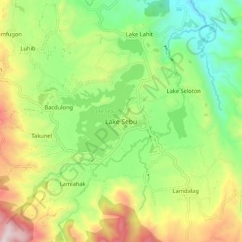
Nom : Carte topographique Lake Sebu, altitude, relief.

Lieu : Lake Sebu, South Cotabato, Soccsksargen, 9514, Philippines (6.18600 124.67157 6.26600 124.75157)

Altitude moyenne : 750 m

Altitude minimum : 344 m

Altitude maximum : 1.389 m

Autres cartes topographiques

Cliquez sur une carte pour visualiser sa topographie, son altitude et son relief.

Polomolok

Philippines > South Cotabato

Altitude moyenne : 485 m

Koronadal

Philippines > South Cotabato

The city's landscape features a combination of flatlands and gently sloping terrain, with approximately 50.18% of its total land area classified as predominantly flat. It is flanked by the Roxas and Quezon mountain ranges, whose elevations reach between 700 to 800 meters above sea level and gradually slope…

Altitude moyenne : 164 m

Surallah

Philippines > South Cotabato

Altitude moyenne : 419 m

Tupi

Philippines > South Cotabato

Altitude moyenne : 460 m

Tampakan

Philippines > South Cotabato

Altitude moyenne : 285 m

Lake Sebu

Philippines > South Cotabato

The placid lake of Lake Sebu can be found in Allah Valley near the municipality of Surallah, South Cotabato. Surrounded by rolling hills and mountains covered with thick rain forest, the lake has an area of 361.124 hectares (892.36 acres), with an elevation of approximately 1,000 metres (3,300 ft).

Altitude moyenne : 710 m

Lake Holon

Philippines > South Cotabato > T'Boli

Altitude moyenne : 1.452 m

Silway River

Philippines > South Cotabato > Polomolok

Altitude moyenne : 257 m

Caloocan

Philippines > South Cotabato > Koronadal

Altitude moyenne : 42 m

San Jose

Philippines > South Cotabato > Koronadal

Altitude moyenne : 102 m

Paraiso

Philippines > South Cotabato > Koronadal

Altitude moyenne : 104 m

Zone III

Philippines > South Cotabato > Koronadal

Altitude moyenne : 82 m

Saravia

Philippines > South Cotabato > Koronadal

Altitude moyenne : 273 m

Rotonda

Philippines > South Cotabato > Koronadal

Altitude moyenne : 57 m

Makar River

Philippines > South Cotabato > General Santos

Altitude moyenne : 277 m

T'Boli

Philippines > South Cotabato

Altitude moyenne : 755 m

Makar River

Philippines > South Cotabato > General Santos

Altitude moyenne : 277 m

Koronadal

Philippines > South Cotabato

Altitude moyenne : 164 m

Polomolok

Philippines > South Cotabato

Altitude moyenne : 485 m

Polomolok

Philippines > South Cotabato

Altitude moyenne : 498 m

T'Boli

Philippines > South Cotabato

Altitude moyenne : 792 m

Tupi

Philippines > South Cotabato

Altitude moyenne : 457 m

Topland

Philippines > South Cotabato > Koronadal

Altitude moyenne : 147 m

Lake Sebu

Philippines > South Cotabato

The placid lake of Lake Sebu can be found in Allah Valley near the municipality of Surallah, South Cotabato. Surrounded by rolling hills and mountains covered with thick rain forest, the lake has an area of 361.124 hectares (892.36 acres), with an elevation of approximately 1,000 metres (3,300 ft).

Altitude moyenne : 710 m

T'Boli

Philippines > South Cotabato

Altitude moyenne : 755 m

Polomolok

Philippines > South Cotabato

Altitude moyenne : 485 m

Koronadal

Philippines > South Cotabato

Altitude moyenne : 164 m

Magsaysay

Philippines > South Cotabato > Koronadal

Altitude moyenne : 93 m

Allah River

Philippines > South Cotabato > Lake Sebu

Altitude moyenne : 792 m

Équipez-vous pour votre prochaine aventure :

🔋Adaptateurs de Prise - Pour les touristes explorant la Belgique
🧴Crèmes Anti-Frottement - Confort maximal pour les longues distances
📕Livres de topographie - Bases du relief et du terrain
🪢Bâtons de trekking - Aide à la marche sur terrains accidentés
🧢Bonnets de randonnée - Protection thermique légère

En tant que Partenaire Amazon, ce site perçoit une commission sur les achats éligibles sans surcoût pour vous.