
Carte topographique Rangeworthy
Carte interactive
Cliquez sur la carte pour afficher l’altitude.
À propos de cette carte
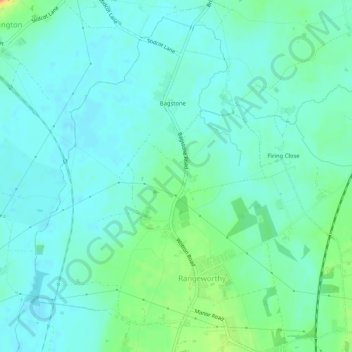
Nom : Carte topographique Rangeworthy, altitude, relief.
Altitude moyenne : 59 m
Altitude minimum : 48 m
Altitude maximum : 93 m
Autres cartes topographiques
Cliquez sur une carte pour visualiser sa topographie, son altitude et son relief.
Warmley
United Kingdom > England > South Gloucestershire
Warmley, Siston, South Gloucestershire, West of England, England, BS15 4PP, United Kingdom
Altitude moyenne : 69 m
Marsh Common
United Kingdom > England > South Gloucestershire > Easter Compton
Marsh Common, Pilning and Severn Beach, Easter Compton, South Gloucestershire, West of England, England, BS35 4JU, United Kingdom
Altitude moyenne : 10 m
Yate
United Kingdom > England > South Gloucestershire
Yate, South Gloucestershire, West of England, England, United Kingdom
Altitude moyenne : 83 m
Siston
United Kingdom > England > South Gloucestershire
Siston, South Gloucestershire, West of England, England, United Kingdom
Altitude moyenne : 80 m
Alveston
United Kingdom > England > South Gloucestershire
Alveston, South Gloucestershire, West of England, England, United Kingdom
Altitude moyenne : 75 m
Kingswood
United Kingdom > England > South Gloucestershire
Kingswood, South Gloucestershire, West of England, England, BS15 8LQ, United Kingdom
Altitude moyenne : 57 m