
Carte topographique Grenchen
Carte interactive
Cliquez sur la carte pour afficher l’altitude.
À propos de cette carte
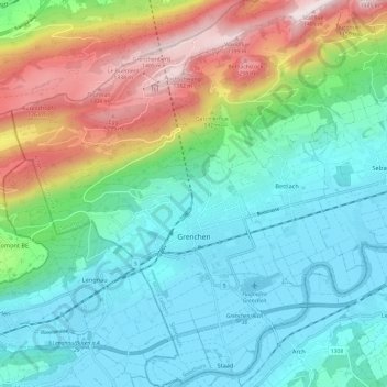
Nom : Carte topographique Grenchen, altitude, relief.
Altitude moyenne : 705 m
Altitude minimum : 424 m
Altitude maximum : 1.411 m
The municipality is the capital of the Lebern District. It is the second largest city in the Canton of Solothurn. The municipality stretches from the hamlet of Staad along the Aare river, (at an elevation of 430 m (1,410 ft)) to the first mountain range of the Jura Mountains (the Oberer Grenchenberg is 1,348 m (4,423 ft)).