
Carte topographique The Peaks
Carte interactive
Cliquez sur la carte pour afficher l’altitude.
À propos de cette carte
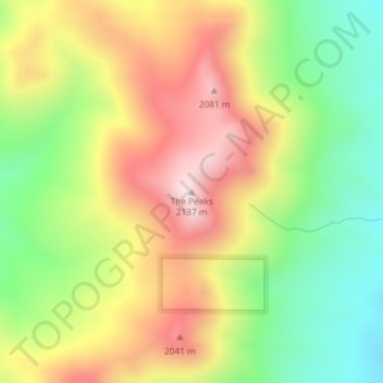
Nom : Carte topographique The Peaks, altitude, relief.
Lieu : The Peaks, Harney County, Oregon, United States of America (42.38270 -118.70028 42.38280 -118.70018)
Altitude moyenne : 1.825 m
Altitude minimum : 1.551 m
Altitude maximum : 2.127 m
Autres cartes topographiques
Cliquez sur une carte pour visualiser sa topographie, son altitude et son relief.
Cascade Range
United States of America > Oregon
Cascade Range, Marion County, Oregon, United States of America
Altitude moyenne : 690 m
Springfield
United States of America > Oregon > Springfield > Springfield
Springfield, Lane County, Oregon, 97477-2635, United States of America
Altitude moyenne : 226 m
Washington Park
United States of America > Oregon > Portland
Washington Park, 4033, Arlington Heights, Portland, Multnomah County, Oregon, 97221, United States of America
Altitude moyenne : 169 m
Necanicum River
United States of America > Oregon
Necanicum River, Clatsop County, Oregon, 97138, United States of America
Altitude moyenne : 185 m
Imnaha River Woods Development
United States of America > Oregon > Imnaha River Woods Development
Imnaha River Woods Development, Wallowa County, Oregon, United States of America
Altitude moyenne : 1.331 m
Crescent Lake
United States of America > Oregon > Crescent Lake
Odell Lake, Crescent Lake, Klamath County, Oregon, United States of America
Altitude moyenne : 1.492 m
Pine Point
United States of America > Oregon
Pine Point, Curry County, Oregon, United States of America
Altitude moyenne : 353 m
The Villages at Mount Hood
United States of America > Oregon
The Villages at Mount Hood, Clackamas County, Oregon, United States of America
Altitude moyenne : 797 m
Charleston
United States of America > Oregon > Charleston
Charleston, Coos County, Oregon, United States of America
Altitude moyenne : 24 m
Riddle
United States of America > Oregon > Riddle
Riddle, Douglas County, Oregon, United States of America
Altitude moyenne : 246 m
Scholls
United States of America > Oregon > Scholls
Scholls, Washington County, Oregon, United States of America
Altitude moyenne : 52 m
Buxton
United States of America > Oregon > Buxton
Buxton, Washington County, Oregon, 97125, United States of America
Altitude moyenne : 146 m
Iron Knob
United States of America > Oregon
Iron Knob, Jackson County, Oregon, United States of America
Altitude moyenne : 861 m
Tillamook
United States of America > Oregon > Tillamook > Tillamook
Tillamook, Tillamook County, Oregon, United States of America
Altitude moyenne : 4 m
Cape Blanco
United States of America > Oregon
Cape Blanco, Cape Blanco Road, Curry County, Oregon, United States of America
Altitude moyenne : 9 m
Tierra Del Mar
United States of America > Oregon > Tierra Del Mar
Tierra Del Mar, Tillamook County, Oregon, 97135, United States of America
Altitude moyenne : 67 m
Horse Ridge
United States of America > Oregon
Horse Ridge, Deschutes County, Oregon, United States of America
Altitude moyenne : 1.390 m
Table Rock
United States of America > Oregon > Brookings
Table Rock, Brookings, Curry County, Oregon, 97415, United States of America
Altitude moyenne : 242 m
Lebanon Dam
United States of America > Oregon
Lebanon Dam, Linn County, Oregon, United States of America
Altitude moyenne : 149 m
Boring
United States of America > Oregon > Boring
Boring, Clackamas County, Oregon, 97009, United States of America
Altitude moyenne : 183 m
Upper Highland
United States of America > Oregon > Upper Highland
Upper Highland, Clackamas County, Oregon, United States of America
Altitude moyenne : 365 m
Tick Hill
United States of America > Oregon
Tick Hill, Wallowa County, Oregon, 97885, United States of America
Altitude moyenne : 990 m