
Carte topographique Portland
Carte interactive
Cliquez sur la carte pour afficher l’altitude.
À propos de cette carte
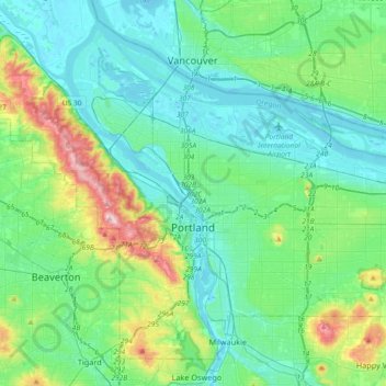
Nom : Carte topographique Portland, altitude, relief.
Lieu : Portland, Multnomah County, Oregon, United States (45.43254 -122.83675 45.65288 -122.47203)
Altitude moyenne : 77 m
Altitude minimum : -5 m
Altitude maximum : 382 m
Annual snowfall in Portland is 4.3 inches (10.9 cm), which usually falls between December and March. The city of Portland avoids snow more frequently than its suburbs, due in part to its low elevation and the urban heat island effect. Neighborhoods outside of the downtown core, especially in slightly higher elevations near the West Hills and Mount Tabor, can experience a dusting of snow while downtown receives no accumulation at all. The city has experienced a few major snow and ice storms in its past, with extreme totals having reached 44.5 in (113 cm) at the airport in 1949–50 and 60.9 in (155 cm) at downtown in 1892–93.