
Carte topographique Tigkan
Cliquez sur la carte pour afficher l’altitude.
À propos de cette carte
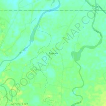
Nom : Carte topographique Tigkan, altitude, relief.
Lieu : Tigkan, Oriental Mindoro, Mimaropa, Philippines (13.26383 121.16145 13.30383 121.20145)
Altitude moyenne : 16 m
Altitude minimum : 9 m
Altitude maximum : 24 m
Autres cartes topographiques
Cliquez sur une carte pour visualiser sa topographie, son altitude et son relief.
Calapan
Philippines > Oriental Mindoro
The overall land characteristic is a wide plain with rivers, interspersed with wetlands at the seacoast periphery. The highest elevation is 187 m (614 ft) above sea level at Bulusan Hill, a 6-kilometre (3.7 mi) long landform east of the city, which interrupts the mostly flat terrain north-east of the…
Altitude moyenne : 12 m
Naujan Lake
Philippines > Oriental Mindoro > Malabo
Mount Naujan, elevation 1,380 feet (420 m) and one of the inactive volcanoes of the country, is situated northeast of the geographic center of the lake. Several thermal springs and solfataras are reported to exist on the eastern border of the Naujan Lake.
Altitude moyenne : 46 m
Calapan
Philippines > Oriental Mindoro
The overall land characteristic is a wide plain with rivers, interspersed with wetlands at the seacoast periphery. The highest elevation is 187 m (614 ft) above sea level at Bulusan Hill, a 6-kilometre (3.7 mi) long landform east of the city, which interrupts the mostly flat terrain north-east of the…
Altitude moyenne : 12 m