
Faire un don
Équipez-vous pour votre prochaine aventure :
En tant que Partenaire Amazon, ce site perçoit une commission sur les achats éligibles sans surcoût pour vous.
Carte topographique Plymouth
Cliquez sur la carte pour afficher l’altitude.
Faire un don
Équipez-vous pour votre prochaine aventure :
En tant que Partenaire Amazon, ce site perçoit une commission sur les achats éligibles sans surcoût pour vous.
À propos de cette carte
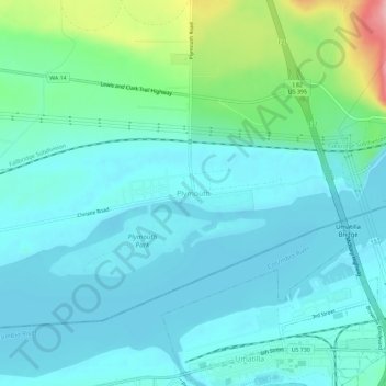
Nom : Carte topographique Plymouth, altitude, relief.
Lieu : Plymouth, Benton County, Washington, 99346, United States (45.91452 -119.37092 45.95452 -119.33092)
Altitude moyenne : 105 m
Altitude minimum : 78 m
Altitude maximum : 218 m
Faire un don
Équipez-vous pour votre prochaine aventure :
En tant que Partenaire Amazon, ce site perçoit une commission sur les achats éligibles sans surcoût pour vous.
Autres cartes topographiques
Cliquez sur une carte pour visualiser sa topographie, son altitude et son relief.
Kennewick
United States > Washington > Benton County
Native Americans populated the area around modern-day Kennewick for millennia before being discovered and settled by European descendants. These inhabitants consisted of people from the Umatilla, Wanapum, Nez Perce, and Yakama tribes. Kennewick's low elevation helped to moderate winter temperatures. On top of…
Altitude moyenne : 157 m
Faire un don
Équipez-vous pour votre prochaine aventure :
En tant que Partenaire Amazon, ce site perçoit une commission sur les achats éligibles sans surcoût pour vous.
West Richland
United States > Washington > Benton County
The original people of the region were the Chemnapum Indians (closely related to the Wanapum tribe), living near the mouth of the Yakima River. Lewis and Clark passed through the area in 1805, and an expedition of the Army Corps of Topographical Engineers headed by Robert E Johnson mapped the Yakima Valley in…
Altitude moyenne : 146 m
Richland
United States > Washington > Benton County
According to the United States Census Bureau, the city has a total area of 39.11 square miles (101.29 km2), of which, 35.72 square miles (92.51 km2) is land and 3.39 square miles (8.78 km2) is water. Elevation at the airport is 120 m (390 ft).
Altitude moyenne : 164 m
Faire un don
Équipez-vous pour votre prochaine aventure :
En tant que Partenaire Amazon, ce site perçoit une commission sur les achats éligibles sans surcoût pour vous.
Kennewick
United States > Washington > Benton County
Native Americans populated the area around modern-day Kennewick for millennia before being discovered and settled by European descendants. These inhabitants consisted of people from the Umatilla, Wanapum, Nez Perce, and Yakama tribes. Kennewick's low elevation helped to moderate winter temperatures. On top of…
Altitude moyenne : 157 m