
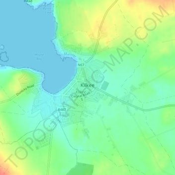
Carte topographique Kilkee
Carte interactive
Cliquez sur la carte pour afficher l’altitude.
À propos de cette carte
Nom : Carte topographique Kilkee, altitude, relief.
Lieu : Kilkee, County Clare, Munster, Ireland (52.66912 -9.66438 52.68844 -9.63096)
Altitude moyenne : 17 m
Altitude minimum : 0 m
Altitude maximum : 50 m
Autres cartes topographiques
Cliquez sur une carte pour visualiser sa topographie, son altitude et son relief.
Kilmihil
Kilmihil, West Clare Municipal District, County Clare, Munster, Ireland
Altitude moyenne : 69 m
Carrigaholt
Carrigaholt, West Clare Municipal District, County Clare, Munster, Ireland
Altitude moyenne : 15 m
Newquay
Newquay, Abbey ED, West Clare Municipal District, County Clare, Munster, Ireland
Altitude moyenne : 7 m
Kilrush
Kilrush, West Clare Municipal District, County Clare, Munster, Ireland
Altitude moyenne : 22 m
Colmanstown
Colmanstown, Killofin ED, West Clare Municipal District, County Clare, Munster, Ireland
Altitude moyenne : 24 m
Dehomad
Dehomad, Clondagad ED, West Clare Municipal District, County Clare, Munster, Ireland
Altitude moyenne : 130 m
Lissycasey
Lissycasey, West Clare Municipal District, County Clare, Munster, Ireland
Altitude moyenne : 101 m
Miltown Malbay
Miltown Malbay, Milltown Malbay ED, West Clare Municipal District, County Clare, Munster, Ireland
Altitude moyenne : 47 m
Bunratty
Bunratty, Drumline ED, Shannon Municipal District, County Clare, Munster, Ireland
Altitude moyenne : 9 m
Ennis
Ennis, Ennis Municipal District, County Clare, Munster, Ireland
Altitude moyenne : 21 m
Feakle
Feakle, Killaloe Municipal District, County Clare, Munster, Ireland
Altitude moyenne : 109 m
Affick
Affick, Newgrove ED, Killaloe Municipal District, County Clare, Munster, Ireland
Altitude moyenne : 128 m
Mullagh
Mullagh, West Clare Municipal District, County Clare, Munster, V95 EP8Y, Ireland
Altitude moyenne : 42 m
Killaderry (O'Brien)
Killaderry (O'Brien), Kilseily ED, Killaloe Municipal District, County Clare, Munster, Ireland
Altitude moyenne : 72 m
Barefield
Barefield, Templemaley ED, Ennis Municipal District, County Clare, Munster, Ireland
Altitude moyenne : 21 m
Doonbeg
Doonbeg, West Clare Municipal District, County Clare, Munster, Ireland
Altitude moyenne : 11 m
Kiltumper
Kiltumper, Glenmore ED, West Clare Municipal District, County Clare, Munster, Ireland
Altitude moyenne : 91 m
Doonaha West
Doonaha West, Moyarta Electoral Division, West Clare Municipal District, County Clare, Munster, Ireland
Altitude moyenne : 23 m
Slieve Elva
Slieve Elva, West Clare Municipal District, County Clare, Munster, Ireland
Altitude moyenne : 256 m
Kilshanny
Kilshanny, Kilshanny ED, West Clare Municipal District, County Clare, Munster, V95 T85K, Ireland
Altitude moyenne : 52 m
Ennis
Ireland > County Clare > Ennis
Ennis, Ennis Municipal District, County Clare, Munster, V95NVF1, Ireland
Altitude moyenne : 20 m
Leadmore East
Leadmore East, Kilrush Rural ED, West Clare Municipal District, County Clare, Munster, V15 PC56, Ireland
Altitude moyenne : 21 m
Cliffs of Moher
Cliffs of Moher, Ballysteen ED, West Clare Municipal District, County Clare, Munster, Ireland
Altitude moyenne : 55 m
Kilmihil
Kilmihil, Kilmihil ED, West Clare Municipal District, County Clare, Munster, Ireland
Altitude moyenne : 67 m
Ennistimon
Ennistimon, Ennistimon ED, West Clare Municipal District, County Clare, Munster, Ireland
Altitude moyenne : 54 m
Errina Canal
Errina Canal, Cappavilla ED, Shannon Municipal District, County Clare, Munster, V94 2N96, Ireland
Altitude moyenne : 11 m
Doonass
Doonass, Kiltenanlea ED, Shannon Municipal District, County Clare, Munster, Ireland
Altitude moyenne : 28 m
Ballyea North
Ballyea North, Ballyea ED, West Clare Municipal District, County Clare, Munster, Ireland
Altitude moyenne : 70 m
Poulbaun
Poulbaun, Corrofin ED, West Clare Municipal District, County Clare, Munster, Ireland
Altitude moyenne : 35 m
Corrifin Superintendent Registrars District
Corrifin Superintendent Registrars District, County Clare, Munster, H91 R9FX, Ireland
Altitude moyenne : 71 m
Mountshannon
Mountshannon, Mountshannon ED, Killaloe Municipal District, County Clare, Munster, Ireland
Altitude moyenne : 56 m
Lough Bunny
Lough Bunny, Boston ED, West Clare Municipal District, County Clare, Munster, Ireland
Altitude moyenne : 23 m
Fitz's Cross
Ireland > County Clare > Doolin
Fitz's Cross, Doolin, Killilagh ED, West Clare Municipal District, County Clare, Munster, V95 DE2X, Ireland
Altitude moyenne : 53 m
Ennis Municipal District
Ennis Municipal District, County Clare, Munster, Ireland
Altitude moyenne : 39 m
Kilkishen
Kilkishen, Killaloe Municipal District, County Clare, Munster, Ireland
Altitude moyenne : 31 m
Meelick
Ireland > County Clare > Meelick
Meelick, Shannon Municipal District, County Clare, Munster, V94 EC5T, Ireland
Altitude moyenne : 46 m
Crusheen
Ireland > County Clare > Crusheen
Crusheen, Killaloe Municipal District, County Clare, Munster, V95 A5F2, Ireland
Altitude moyenne : 36 m
Rosneillan
Rosneillan, Killuran ED, Killaloe Municipal District, County Clare, Munster, Ireland
Altitude moyenne : 39 m
Knock
Knock, Kilcloher ED, West Clare Municipal District, County Clare, Munster, Ireland
Altitude moyenne : 61 m
Knockaunroe
Knockaunroe, Dysert ED, West Clare Municipal District, County Clare, Munster, Ireland
Altitude moyenne : 92 m
Bridgetown
Ireland > County Clare > Bridgetown
Bridgetown, Killaloe Municipal District, County Clare, Munster, Ireland
Altitude moyenne : 68 m
Caher (Power)
Caher (Power), Derrynagittagh ED, Killaloe Municipal District, County Clare, Munster, Ireland
Altitude moyenne : 68 m
Bealaha
Bealaha, Knocknagore ED, West Clare Municipal District, County Clare, Munster, V15 DH28, Ireland
Altitude moyenne : 17 m
Knockbeha
Knockbeha, Corlea ED, Killaloe Municipal District, County Clare, Munster, Ireland
Altitude moyenne : 121 m
Aglish
Aglish, Glenroe ED, West Clare Municipal District, County Clare, Munster, Ireland
Altitude moyenne : 27 m
Foohagh Point
Foohagh Point, Kilfearagh ED, West Clare Municipal District, County Clare, Munster, Ireland
Altitude moyenne : 24 m
Ennistimon
Ireland > County Clare > Ennistimon
Ennistimon, West Clare Municipal District, County Clare, Munster, Ireland
Altitude moyenne : 61 m
Knocknagarhoon
Knocknagarhoon, Tullig ED, West Clare Municipal District, County Clare, Munster, Ireland
Altitude moyenne : 45 m
Kilchreest
Kilchreest, West Clare Municipal District, County Clare, Munster, Ireland
Altitude moyenne : 35 m
Breaffy South
Breaffy South, Milltown Malbay ED, West Clare Municipal District, County Clare, Munster, Ireland
Altitude moyenne : 13 m