
Faire un don
Équipez-vous pour votre prochaine aventure :
En tant que Partenaire Amazon, ce site perçoit une commission sur les achats éligibles sans surcoût pour vous.
Carte topographique Ponte Vedra Beach
Cliquez sur la carte pour afficher l’altitude.
Faire un don
Équipez-vous pour votre prochaine aventure :
En tant que Partenaire Amazon, ce site perçoit une commission sur les achats éligibles sans surcoût pour vous.
Ponte Vedra Beach
Ponte Vedra Beach is characterized by its gently rolling terrain that is primarily flat and lies only about 15 feet above sea level. The landscape is predominantly shaped by coastal dunes and the proximity to the Atlantic Ocean, resulting in sandy beaches interspersed with vegetation typical of barrier island ecosystems. The area is part of the Guana Tolomato Matanzas National Estuarine Research Reserve, which contributes to its diverse coastal habitats, including estuaries and wetlands. This low-lying terrain is susceptible to erosion and sea level rise, making its elevation a crucial factor in environmental discussions. The interplay between the beach, dunes, and coastal wetlands creates a unique and rich ecosystem that attracts both residents and visitors seeking natural beauty and outdoor activities.
Faire un don
Équipez-vous pour votre prochaine aventure :
En tant que Partenaire Amazon, ce site perçoit une commission sur les achats éligibles sans surcoût pour vous.
À propos de cette carte
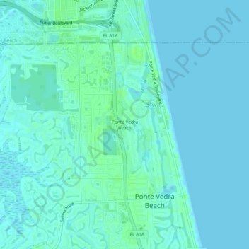
Nom : Carte topographique Ponte Vedra Beach, altitude, relief.
Altitude moyenne : 3 m
Altitude minimum : -1 m
Altitude maximum : 9 m
Faire un don
Équipez-vous pour votre prochaine aventure :
En tant que Partenaire Amazon, ce site perçoit une commission sur les achats éligibles sans surcoût pour vous.
Autres cartes topographiques
Cliquez sur une carte pour visualiser sa topographie, son altitude et son relief.
DeLeon Shores Park
United States > Florida > Saint Johns County > Ponte Vedra Beach > Palm Valley
Altitude moyenne : 4 m
Faire un don
Équipez-vous pour votre prochaine aventure :
En tant que Partenaire Amazon, ce site perçoit une commission sur les achats éligibles sans surcoût pour vous.