
Faire un don
Équipez-vous pour votre prochaine aventure :
En tant que Partenaire Amazon, ce site perçoit une commission sur les achats éligibles sans surcoût pour vous.
Carte topographique Northbrook
Cliquez sur la carte pour afficher l’altitude.
Faire un don
Équipez-vous pour votre prochaine aventure :
En tant que Partenaire Amazon, ce site perçoit une commission sur les achats éligibles sans surcoût pour vous.
À propos de cette carte
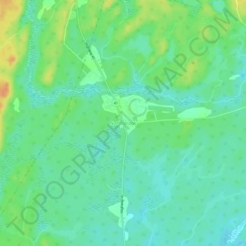
Nom : Carte topographique Northbrook, altitude, relief.
Altitude moyenne : 260 m
Altitude minimum : 247 m
Altitude maximum : 284 m
Faire un don
Équipez-vous pour votre prochaine aventure :
En tant que Partenaire Amazon, ce site perçoit une commission sur les achats éligibles sans surcoût pour vous.
Autres cartes topographiques
Cliquez sur une carte pour visualiser sa topographie, son altitude et son relief.
Joeperry Lake
Canada > Ontario > Lennox and Addington County > Addington Highlands
Joeperry Lake is the source of the Skootamatta River. It is about 2.2 kilometres (1.4 mi) long and 2.2 kilometres (1.4 mi) wide, and lies at an elevation of 315 metres (1,033 ft). There is one inflow, an unnamed creek at the west of the lake. The primary outflow is the Skootamatta River, on the south side of…
Altitude moyenne : 328 m
Bon Echo Provincial Park
Canada > Ontario > Lennox and Addington County > Addington Highlands
Altitude moyenne : 321 m
Bon Echo Lake
Canada > Ontario > Lennox and Addington County > Addington Highlands
Altitude moyenne : 313 m
Upper Mazinaw Lake
Canada > Ontario > Lennox and Addington County > Addington Highlands
Altitude moyenne : 296 m
Faire un don
Équipez-vous pour votre prochaine aventure :
En tant que Partenaire Amazon, ce site perçoit une commission sur les achats éligibles sans surcoût pour vous.
Denbigh Lake
Canada > Ontario > Lennox and Addington County > Addington Highlands > Denbigh
Altitude moyenne : 372 m
Grimsthorpe Lake
Canada > Ontario > Lennox and Addington County > Addington Highlands
Altitude moyenne : 336 m
Skootamatta Lake
Canada > Ontario > Lennox and Addington County > Addington Highlands
Altitude moyenne : 301 m
Weslemkoon Lake
Canada > Ontario > Lennox and Addington County > Addington Highlands
Altitude moyenne : 349 m
Faire un don
Équipez-vous pour votre prochaine aventure :
En tant que Partenaire Amazon, ce site perçoit une commission sur les achats éligibles sans surcoût pour vous.
Bon Echo Provincial Park
Canada > Ontario > Lennox and Addington County > Addington Highlands
Altitude moyenne : 321 m