
Carte topographique Мякса
Carte interactive
Cliquez sur la carte pour afficher l’altitude.
À propos de cette carte
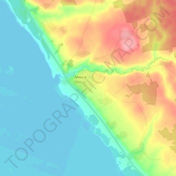
Nom : Carte topographique Мякса, altitude, relief.
Altitude moyenne : 127 m
Altitude minimum : 96 m
Altitude maximum : 190 m
Autres cartes topographiques
Cliquez sur une carte pour visualiser sa topographie, son altitude et son relief.
Мякса
Россия > Вологодская область > Череповецкий район > Мякса
Мякса, Мяксинское сельское поселение, Череповецкий район, Вологодская область, Северо-Западный федеральный округ, 162646, Россия
Altitude moyenne : 127 m