
Faire un don
Équipez-vous pour votre prochaine aventure :
En tant que Partenaire Amazon, ce site perçoit une commission sur les achats éligibles sans surcoût pour vous.
Carte topographique Sikar
Cliquez sur la carte pour afficher l’altitude.
Faire un don
Équipez-vous pour votre prochaine aventure :
En tant que Partenaire Amazon, ce site perçoit une commission sur les achats éligibles sans surcoût pour vous.
À propos de cette carte
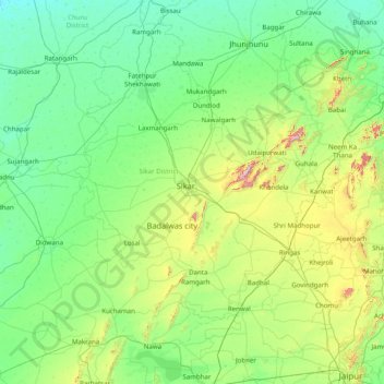
Nom : Carte topographique Sikar, altitude, relief.
Lieu : Sikar, Sikar District, Rajasthan, 332001, India (26.88333 74.46667 28.28333 75.86667)
Altitude moyenne : 394 m
Altitude minimum : 275 m
Altitude maximum : 1.027 m
Faire un don
Équipez-vous pour votre prochaine aventure :
En tant que Partenaire Amazon, ce site perçoit une commission sur les achats éligibles sans surcoût pour vous.
Autres cartes topographiques
Cliquez sur une carte pour visualiser sa topographie, son altitude et son relief.
Jalore
The district is bounded on the northwest by Barmer District, on the northeast by Pali District, on the southeast by Sirohi District, and by Banaskantha District of Gujarat state on the southwest. The total area of the district is 10,640 km2 (4,108 sq mi). The altitude is 268 m, latitude is 25.22 N and…
Altitude moyenne : 183 m
Faire un don
Équipez-vous pour votre prochaine aventure :
En tant que Partenaire Amazon, ce site perçoit une commission sur les achats éligibles sans surcoût pour vous.
Faire un don
Équipez-vous pour votre prochaine aventure :
En tant que Partenaire Amazon, ce site perçoit une commission sur les achats éligibles sans surcoût pour vous.
Faire un don
Équipez-vous pour votre prochaine aventure :
En tant que Partenaire Amazon, ce site perçoit une commission sur les achats éligibles sans surcoût pour vous.
Hindaun
India > Rajasthan > Hindaun Tehsil
Hindaun has an average elevation of 235 metres (771 ft). Its distance from the state capital of Jaipur is around 150 km.
Altitude moyenne : 230 m
Pokaran
India > Rajasthan > Pokaran Tehsil
Pokhran is located 112 km east of Jaisalmer city, 172 km northwest of Jodhpur and 225 km south of Bikaner by road. It lies on Jaisalmer to Jodhpur railway line. It is situated at 27°05′42″N 71°45′11″E / 27.095°N 71.753°E / 27.095; 71.753 and has an average elevation of 233 metres (764 feet).
Altitude moyenne : 229 m
Faire un don
Équipez-vous pour votre prochaine aventure :
En tant que Partenaire Amazon, ce site perçoit une commission sur les achats éligibles sans surcoût pour vous.
Faire un don
Équipez-vous pour votre prochaine aventure :
En tant que Partenaire Amazon, ce site perçoit une commission sur les achats éligibles sans surcoût pour vous.
Sirohi
India > Rajasthan > Sirohi Tehsil
Sirohi is located at 24°53′06″N 72°51′45″E / 24.885°N 72.8625°E / 24.885; 72.8625. It has an average elevation of 321 metres (1053 ft).
Altitude moyenne : 321 m
Dausa
The general topographic elevation in the district is between 250 m to 300 m above sea level. Elevation ranges from a minimum of 203.2 m above sea level in Mahwa in the northeastern part of the district and maximum of 596.3 m above sea level in Bandikui in northern part of the district.
Altitude moyenne : 313 m
Faire un don
Équipez-vous pour votre prochaine aventure :
En tant que Partenaire Amazon, ce site perçoit une commission sur les achats éligibles sans surcoût pour vous.
Karauli
The Chambal River forms the south-eastern boundary of the district, 5 km from Mandrayal across which lies the state of Madhya Pradesh. While almost the entire district is covered by hills and ravines, there are no lofty peaks, the highest having an elevation of less than 1400 feet above sea level.
Altitude moyenne : 263 m
Faire un don
Équipez-vous pour votre prochaine aventure :
En tant que Partenaire Amazon, ce site perçoit une commission sur les achats éligibles sans surcoût pour vous.
Faire un don
Équipez-vous pour votre prochaine aventure :
En tant que Partenaire Amazon, ce site perçoit une commission sur les achats éligibles sans surcoût pour vous.
karauli
India > Rajasthan > Karauli Tehsil
Karauli is located at 26°30′N 77°01′E / 26.5°N 77.02°E / 26.5; 77.02. It has an average elevation of 275 metres (902 ft).
Altitude moyenne : 273 m
Faire un don
Équipez-vous pour votre prochaine aventure :
En tant que Partenaire Amazon, ce site perçoit une commission sur les achats éligibles sans surcoût pour vous.
Faire un don
Équipez-vous pour votre prochaine aventure :
En tant que Partenaire Amazon, ce site perçoit une commission sur les achats éligibles sans surcoût pour vous.
Faire un don
Équipez-vous pour votre prochaine aventure :
En tant que Partenaire Amazon, ce site perçoit une commission sur les achats éligibles sans surcoût pour vous.
Faire un don
Équipez-vous pour votre prochaine aventure :
En tant que Partenaire Amazon, ce site perçoit une commission sur les achats éligibles sans surcoût pour vous.