
Carte topographique Panaji
Carte interactive
Cliquez sur la carte pour afficher l’altitude.
Panaji
Panaji was annexed by India with the rest of Goa and the former Portuguese territories after the Indian annexation of Portuguese India in 1961. It became a state-capital on Goa's elevation to statehood in 1987. Between 1961 and 1987, it was the capital of the Union Territory of Goa, Daman and Diu. A new Legislative Assembly complex was inaugurated in March 2000, across the Mandovi River, in Alto Porvorim. Panaji is also the administrative headquarters of North Goa district.
À propos de cette carte
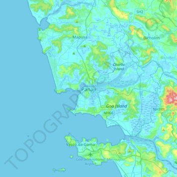
Nom : Carte topographique Panaji, altitude, relief.
Lieu : Panaji, Tiswadi, North Goa, Goa, 403001, India (15.33899 73.66821 15.65899 73.98821)
Altitude moyenne : 19 m
Altitude minimum : -3 m
Altitude maximum : 285 m
Autres cartes topographiques
Cliquez sur une carte pour visualiser sa topographie, son altitude et son relief.