
Carte topographique Kolašin
Carte interactive
Cliquez sur la carte pour afficher l’altitude.
À propos de cette carte
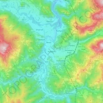
Nom : Carte topographique Kolašin, altitude, relief.
Lieu : Kolašin, Kolašin Municipality, 81210, Montenegro (42.78385 19.48180 42.86385 19.56180)
Altitude moyenne : 1.133 m
Altitude minimum : 897 m
Altitude maximum : 1.669 m
Kolašin is located on the foot of Bjelasica and Sinjajevina mountains, which offer great conditions for skiing. Because of Kolašin's altitude (954 m), the town is considered an air spa.