
Carte topographique Inkerman
Carte interactive
Cliquez sur la carte pour afficher l’altitude.
À propos de cette carte
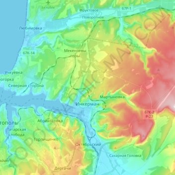
Nom : Carte topographique Inkerman, altitude, relief.
Lieu : Inkerman, Sevastopol, Southern Federal District, Russia (44.57913 33.56723 44.67871 33.73316)
Altitude moyenne : 97 m
Altitude minimum : -3 m
Altitude maximum : 306 m
Autres cartes topographiques
Cliquez sur une carte pour visualiser sa topographie, son altitude et son relief.
Маячная балка
Russia > Sevastopol > Inkerman
Маячная балка, Inkerman, Sevastopol, Southern Federal District, Russia
Altitude moyenne : 47 m
Бомборы
Russia > Sevastopol > Sevastopol
Бомборы, Нахимовский округ, Sevastopol, Southern Federal District, Russia
Altitude moyenne : 56 m