Carte topographique Hurlach
Carte interactive
Cliquez sur la carte pour afficher l’altitude.
À propos de cette carte
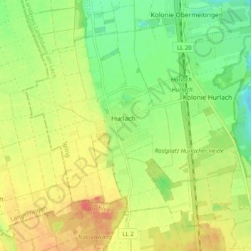
Autres cartes topographiques
Cliquez sur une carte pour visualiser sa topographie, son altitude et son relief.
![Carte topographique Ammersee, altitude, relief](/pub/maps/relation/jwtf/m7b8z4/icon.jpg)
Ammersee
Deutschland > Bayern > Landkreis Landsberg am Lech
Ammersee, Landkreis Landsberg am Lech, Bayern, Deutschland
Altitude moyenne : 596 m
![Carte topographique Landsberg am Lech, altitude, relief](/pub/maps/relation/vwm2/kqbv57/icon.jpg)
Landsberg am Lech
Deutschland > Bayern > Landkreis Landsberg am Lech
Landsberg am Lech, Landkreis Landsberg am Lech, Bayern, 86899, Deutschland
Altitude moyenne : 626 m
![Carte topographique Lechmühlen, altitude, relief](/pub/maps/node/w74s/c18tlcnx/icon.jpg)
Lechmühlen
Deutschland > Bayern > Landkreis Landsberg am Lech > Fuchstal
Lechmühlen, Fuchstal, Landkreis Landsberg am Lech, Bayern, 86925, Deutschland
Altitude moyenne : 653 m
![Carte topographique 86947, altitude, relief](/pub/maps/relation/9jt6/hb22tp/icon.jpg)
86947
Deutschland > Bayern > Landkreis Landsberg am Lech > Weil
86947, Weil, Landkreis Landsberg am Lech, Bayern, Deutschland
Altitude moyenne : 579 m
![Carte topographique 86946, altitude, relief](/pub/maps/relation/dg4s/9pld5k/icon.jpg)
86946
Deutschland > Bayern > Landkreis Landsberg am Lech > Pflugdorf
86946, Pflugdorf, Vilgertshofen, Reichling, Landkreis Landsberg am Lech, Bayern, Deutschland
Altitude moyenne : 695 m
![Carte topographique 82279, altitude, relief](/pub/maps/relation/k23l/hgfgtp/icon.jpg)
82279
Deutschland > Bayern > Landkreis Landsberg am Lech > Eching am Ammersee
82279, Eching am Ammersee, Schondorf a.Ammersee (VGem), Landkreis Landsberg am Lech, Bayern, Deutschland
Altitude moyenne : 543 m
![Carte topographique 86919, altitude, relief](/pub/maps/relation/lxs8/scphb3/icon.jpg)
86919
Deutschland > Bayern > Landkreis Landsberg am Lech > Utting am Ammersee
86919, Utting am Ammersee, Landkreis Landsberg am Lech, Bayern, Deutschland
Altitude moyenne : 565 m
![Carte topographique Holzhausen bei Buchloe, altitude, relief](/pub/maps/node/xzf3/vj1grrm2/icon.jpg)
Holzhausen bei Buchloe
Deutschland > Bayern > Landkreis Landsberg am Lech
Holzhausen bei Buchloe, Igling, Landkreis Landsberg am Lech, Bayern, 86859, Deutschland
Altitude moyenne : 618 m
![Carte topographique Oberbergen, altitude, relief](/pub/maps/node/x3s8/dhvf67kl/icon.jpg)
Oberbergen
Deutschland > Bayern > Landkreis Landsberg am Lech
Oberbergen, Penzing, Landkreis Landsberg am Lech, Bayern, 86929, Deutschland
Altitude moyenne : 602 m
![Carte topographique Greifenberg, altitude, relief](/pub/maps/relation/54nx/sx9bb3/icon.jpg)
Greifenberg
Deutschland > Bayern > Landkreis Landsberg am Lech
Greifenberg, Schondorf a.Ammersee (VGem), Landkreis Landsberg am Lech, Bayern, 86926, Deutschland
Altitude moyenne : 575 m
![Carte topographique Schöffelding, altitude, relief](/pub/maps/node/g4kl/s9bp2ls8/icon.jpg)
Schöffelding
Deutschland > Bayern > Landkreis Landsberg am Lech
Schöffelding, Windach, Landkreis Landsberg am Lech, Bayern, 86949, Deutschland
Altitude moyenne : 631 m
![Carte topographique Schwifting, altitude, relief](/pub/maps/relation/7n3l/46dgnh/icon.jpg)
Schwifting
Deutschland > Bayern > Landkreis Landsberg am Lech
Schwifting, Pürgen, Landkreis Landsberg am Lech, Bayern, 86940, Deutschland
Altitude moyenne : 634 m
![Carte topographique Pflugdorf, altitude, relief](/pub/maps/node/1ptj/jz9hw4s/icon.jpg)
Pflugdorf
Deutschland > Bayern > Landkreis Landsberg am Lech
Pflugdorf, Vilgertshofen, Reichling, Landkreis Landsberg am Lech, Bayern, 86946, Deutschland
Altitude moyenne : 689 m
![Carte topographique Unterdießen, altitude, relief](/pub/maps/relation/4zm2/kqcm57/icon.jpg)
Unterdießen
Deutschland > Bayern > Landkreis Landsberg am Lech
Unterdießen, Fuchstal, Landkreis Landsberg am Lech, Bayern, 86944, Deutschland
Altitude moyenne : 650 m
![Carte topographique Dießen am Ammersee, altitude, relief](/pub/maps/relation/rftj/18mfm2/icon.jpg)
Dießen am Ammersee
Deutschland > Bayern > Landkreis Landsberg am Lech
Dießen am Ammersee, Landkreis Landsberg am Lech, Bayern, 86911, Deutschland
Altitude moyenne : 594 m
![Carte topographique Welden, altitude, relief](/pub/maps/node/lvgt/2dd5p9m/icon.jpg)
Welden
Deutschland > Bayern > Landkreis Landsberg am Lech > Fuchstal
Welden, Fuchstal, Landkreis Landsberg am Lech, Bayern, 86925, Deutschland
Altitude moyenne : 721 m
![Carte topographique Scheuring, altitude, relief](/pub/maps/relation/7z3l/46d6nh/icon.jpg)
Scheuring
Deutschland > Bayern > Landkreis Landsberg am Lech
Scheuring, Prittriching, Landkreis Landsberg am Lech, Bayern, 86937, Deutschland
Altitude moyenne : 565 m
![Carte topographique Ludenhausen, altitude, relief](/pub/maps/node/lwnh/2t2k1zs/icon.jpg)
Ludenhausen
Deutschland > Bayern > Landkreis Landsberg am Lech
Ludenhausen, Reichling, Landkreis Landsberg am Lech, Bayern, 86934, Deutschland
Altitude moyenne : 708 m
![Carte topographique 86934, altitude, relief](/pub/maps/relation/xc57/pgr1gt/icon.jpg)
86934
Deutschland > Bayern > Landkreis Landsberg am Lech > Reichling
86934, Reichling, Landkreis Landsberg am Lech, Bayern, Deutschland
Altitude moyenne : 710 m
![Carte topographique Leeder, altitude, relief](/pub/maps/node/w7zs/bvjm24s/icon.jpg)
Leeder
Deutschland > Bayern > Landkreis Landsberg am Lech > Fuchstal
Leeder, Fuchstal, Landkreis Landsberg am Lech, Bayern, 86925, Deutschland
Altitude moyenne : 680 m
![Carte topographique Dettenschwang, altitude, relief](/pub/maps/node/q7t6/njwxh51/icon.jpg)
Dettenschwang
Deutschland > Bayern > Landkreis Landsberg am Lech > Dießen am Ammersee
Dettenschwang, Dießen am Ammersee, Landkreis Landsberg am Lech, Bayern, Deutschland
Altitude moyenne : 675 m
![Carte topographique Mundraching, altitude, relief](/pub/maps/node/92s8/r1bfpt6/icon.jpg)
Mundraching
Deutschland > Bayern > Landkreis Landsberg am Lech
Mundraching, Vilgertshofen, Reichling, Landkreis Landsberg am Lech, Bayern, 86925, Deutschland
Altitude moyenne : 657 m
![Carte topographique Kaufering, altitude, relief](/pub/maps/relation/l1tp/fg5n3l/icon.jpg)
Kaufering
Deutschland > Bayern > Landkreis Landsberg am Lech
Kaufering, Landkreis Landsberg am Lech, Bayern, 86916, Deutschland
Altitude moyenne : 589 m
![Carte topographique Igling, altitude, relief](/pub/maps/relation/fj18/dbg5tf/icon.jpg)
Igling
Deutschland > Bayern > Landkreis Landsberg am Lech
Igling, Landkreis Landsberg am Lech, Bayern, 86859, Deutschland
Altitude moyenne : 602 m
![Carte topographique Schondorf am Ammersee, altitude, relief](/pub/maps/relation/xnt6/pfl7gt/icon.jpg)
Schondorf am Ammersee
Deutschland > Bayern > Landkreis Landsberg am Lech
Schondorf am Ammersee, Schondorf a.Ammersee (VGem), Landkreis Landsberg am Lech, Bayern, 86938, Deutschland
Altitude moyenne : 555 m
![Carte topographique Thaining, altitude, relief](/pub/maps/relation/mjgt/hdfwgp/icon.jpg)
Thaining
Deutschland > Bayern > Landkreis Landsberg am Lech
Thaining, Reichling, Landkreis Landsberg am Lech, Bayern, 86943, Deutschland
Altitude moyenne : 682 m
![Carte topographique Sankt Ottilien, altitude, relief](/pub/maps/node/6m9m/zcf4hxkl/icon.jpg)
Sankt Ottilien
Deutschland > Bayern > Landkreis Landsberg am Lech
Sankt Ottilien, Eresing, Windach, Landkreis Landsberg am Lech, Bayern, 86941, Deutschland
Altitude moyenne : 598 m
![Carte topographique Fuchstal, altitude, relief](/pub/maps/relation/vgtj/18sgm2/icon.jpg)
Fuchstal
Deutschland > Bayern > Landkreis Landsberg am Lech
Fuchstal, Landkreis Landsberg am Lech, Bayern, 86925, Deutschland
Altitude moyenne : 691 m
![Carte topographique Prittriching, altitude, relief](/pub/maps/relation/r8tj/18m8m2/icon.jpg)
Prittriching
Deutschland > Bayern > Landkreis Landsberg am Lech
Prittriching, Landkreis Landsberg am Lech, Bayern, 86931, Deutschland
Altitude moyenne : 544 m
![Carte topographique Dornstetten, altitude, relief](/pub/maps/node/zstj/6jwz9m2/icon.jpg)
Dornstetten
Deutschland > Bayern > Landkreis Landsberg am Lech
Dornstetten, Unterdießen, Fuchstal, Landkreis Landsberg am Lech, Bayern, 86944, Deutschland
Altitude moyenne : 638 m
![Carte topographique Penzing, altitude, relief](/pub/maps/relation/nwrr/hdfwtp/icon.jpg)
Penzing
Deutschland > Bayern > Landkreis Landsberg am Lech
Penzing, Landkreis Landsberg am Lech, Bayern, 86929, Deutschland
Altitude moyenne : 610 m
![Carte topographique Geltendorf, altitude, relief](/pub/maps/relation/4wdn/8k7w9m/icon.jpg)
Geltendorf
Deutschland > Bayern > Landkreis Landsberg am Lech
Geltendorf, Landkreis Landsberg am Lech, Bayern, 82269, Deutschland
Altitude moyenne : 586 m
![Carte topographique Kinsau, altitude, relief](/pub/maps/relation/sqz4/7j5rt6/icon.jpg)
Kinsau
Deutschland > Bayern > Landkreis Landsberg am Lech
Kinsau, Reichling, Landkreis Landsberg am Lech, Bayern, 86981, Deutschland
Altitude moyenne : 700 m
![Carte topographique Egling an der Paar, altitude, relief](/pub/maps/relation/3xnh/lwxx4s/icon.jpg)
Egling an der Paar
Deutschland > Bayern > Landkreis Landsberg am Lech > Egling an der Paar
Egling an der Paar, Landkreis Landsberg am Lech, Bayern, 86492, Deutschland
Altitude moyenne : 561 m
![Carte topographique Reichling, altitude, relief](/pub/maps/relation/w457/9zqn5k/icon.jpg)
Reichling
Deutschland > Bayern > Landkreis Landsberg am Lech > Reichling
Reichling, Landkreis Landsberg am Lech, Bayern, 86934, Deutschland
Altitude moyenne : 691 m
![Carte topographique Ammersee, altitude, relief](/pub/maps/relation/k5z4/ln2nh/icon.jpg)
Ammersee
Deutschland > Bayern > Landkreis Landsberg am Lech > Schondorf am Ammersee
Ammersee, Schondorf am Ammersee, Schondorf a.Ammersee (VGem), Landkreis Landsberg am Lech, Bayern, Deutschland
Altitude moyenne : 596 m
![Carte topographique Pessenhausen, altitude, relief](/pub/maps/node/dt4s/6wbbk7tf/icon.jpg)
Pessenhausen
Deutschland > Bayern > Landkreis Landsberg am Lech > Pessenhausen
Pessenhausen, Rott, Reichling, Landkreis Landsberg am Lech, Bayern, 86934, Deutschland
Altitude moyenne : 706 m
![Carte topographique Utting am Ammersee, altitude, relief](/pub/maps/relation/k1tf/m76xz4/icon.jpg)
Utting am Ammersee
Deutschland > Bayern > Landkreis Landsberg am Lech
Utting am Ammersee, Landkreis Landsberg am Lech, Bayern, 86919, Deutschland
Altitude moyenne : 573 m
![Carte topographique Oberdießen, altitude, relief](/pub/maps/node/8hgp/qmv4314/icon.jpg)
Oberdießen
Deutschland > Bayern > Landkreis Landsberg am Lech > Oberdießen
Oberdießen, Unterdießen, Fuchstal, Landkreis Landsberg am Lech, Bayern, 86944, Deutschland
Altitude moyenne : 660 m
![Carte topographique Finning, altitude, relief](/pub/maps/relation/pg51/39kj18/icon.jpg)
Finning
Deutschland > Bayern > Landkreis Landsberg am Lech
Finning, Windach, Landkreis Landsberg am Lech, Bayern, 86923, Deutschland
Altitude moyenne : 635 m
![Carte topographique Denklingen, altitude, relief](/pub/maps/relation/mjmt/sx9qf3/icon.jpg)
Denklingen
Deutschland > Bayern > Landkreis Landsberg am Lech
Denklingen, Landkreis Landsberg am Lech, Bayern, 86920, Deutschland
Altitude moyenne : 728 m
![Carte topographique Eresing, altitude, relief](/pub/maps/relation/hq51/hdzggp/icon.jpg)
Eresing
Deutschland > Bayern > Landkreis Landsberg am Lech
Eresing, Windach, Landkreis Landsberg am Lech, Bayern, Deutschland
Altitude moyenne : 602 m
![Carte topographique Vilgertshofen, altitude, relief](/pub/maps/relation/r6tj/18m6m2/icon.jpg)
Vilgertshofen
Deutschland > Bayern > Landkreis Landsberg am Lech
Vilgertshofen, Reichling, Landkreis Landsberg am Lech, Bayern, 86946, Deutschland
Altitude moyenne : 681 m
![Carte topographique Windach, altitude, relief](/pub/maps/relation/8qtp/fgwc3l/icon.jpg)
Windach
Deutschland > Bayern > Landkreis Landsberg am Lech
Windach, Landkreis Landsberg am Lech, Bayern, 86949, Deutschland
Altitude moyenne : 603 m