
Carte topographique Lindenhurst
Carte interactive
Cliquez sur la carte pour afficher l’altitude.
À propos de cette carte
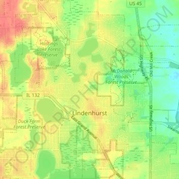
Nom : Carte topographique Lindenhurst, altitude, relief.
Lieu : Lindenhurst, Lake County, Illinois, United States (42.39267 -88.05865 42.44082 -88.00208)
Altitude moyenne : 236 m
Altitude minimum : 211 m
Altitude maximum : 259 m
Autres cartes topographiques
Cliquez sur une carte pour visualiser sa topographie, son altitude et son relief.
Wadsworth
United States > Illinois > Lake County
Wadsworth, Lake County, Illinois, United States
Altitude moyenne : 219 m
Zion
United States > Illinois > Lake County
Zion, Lake County, Illinois, 60099, United States
Altitude moyenne : 198 m
Centenial Park
United States > Illinois > Lake County > Antioch
Centenial Park, Antioch, Lake County, Illinois, United States
Altitude moyenne : 243 m
Gages Lake
United States > Illinois > Lake County > Gages Lake
Gages Lake, Lake County, Illinois, 60031, United States
Altitude moyenne : 236 m
Beach Park
United States > Illinois > Lake County
Beach Park, Lake County, Illinois, United States
Altitude moyenne : 209 m
Round Lake
United States > Illinois > Lake County
Round Lake, Lake County, Illinois, United States
Altitude moyenne : 241 m
Great Lakes
United States > Illinois > Lake County > North Chicago
Great Lakes, North Chicago, Lake County, Illinois, 60088, United States
Altitude moyenne : 201 m
Buffalo Grove
United States > Illinois > Lake County
Buffalo Grove, Lake County, Illinois, 60089, United States
Altitude moyenne : 209 m
Deerpath
United States > Illinois > Lake County > Lake Forest
Deerpath, Lake Forest, Lake County, Illinois, 60045, United States
Altitude moyenne : 209 m
Forest Lake
United States > Illinois > Lake County
Forest Lake, Lake County, Illinois, United States
Altitude moyenne : 250 m
Venetian Village
United States > Illinois > Lake County
Venetian Village, Lake County, Illinois, United States
Altitude moyenne : 241 m
Fox Lake Hills
United States > Illinois > Lake County
Fox Lake Hills, Lake County, Illinois, United States
Altitude moyenne : 232 m
Lake Forest
United States > Illinois > Lake County
Lake Forest, Lake County, Illinois, 60045, United States
Altitude moyenne : 199 m
Bushs Corners
United States > Illinois > Lake County > Libertyville
Bushs Corners, Libertyville, Lake County, Illinois, 60048, United States
Altitude moyenne : 223 m
Lake Barrington
United States > Illinois > Lake County
Lake Barrington, Cuba, Lake County, Illinois, United States
Altitude moyenne : 241 m
Deep Lake
United States > Illinois > Lake County > Lake Villa
Deep Lake, Lake Villa, Lake County, Illinois, United States
Altitude moyenne : 243 m
Fox Lake
United States > Illinois > Lake County
Fox Lake, Lake County, Illinois, 60020, United States
Altitude moyenne : 240 m
Mundelein
United States > Illinois > Lake County
Mundelein, Lake County, Illinois, 60060, United States
Altitude moyenne : 231 m
Lake Zurich
United States > Illinois > Lake County
Lake Zurich, Cuba, Lake County, Illinois, United States
Altitude moyenne : 259 m
Wauconda
United States > Illinois > Lake County
Wauconda, Cuba, Lake County, Illinois, United States
Altitude moyenne : 242 m
Highland Park
United States > Illinois > Lake County
Highland Park, Lake County, Illinois, 60035, United States
Altitude moyenne : 194 m
Antioch
United States > Illinois > Lake County
Antioch, Lake County, Illinois, United States
Altitude moyenne : 238 m
Hawthorn Woods
United States > Illinois > Lake County
Hawthorn Woods, Lake County, Illinois, 60047, United States
Altitude moyenne : 247 m
Bannockburn
United States > Illinois > Lake County
Bannockburn, Lake County, Illinois, United States
Altitude moyenne : 206 m
Green Oaks
United States > Illinois > Lake County
Green Oaks, Lake County, Illinois, United States
Altitude moyenne : 210 m
Long Grove
United States > Illinois > Lake County
Long Grove, Lake County, Illinois, United States
Altitude moyenne : 224 m
Kennedy
United States > Illinois > Lake County > Lake Forest
Kennedy, Lake Forest, Lake County, Illinois, 60045, United States
Altitude moyenne : 207 m
Spaulding Corners
United States > Illinois > Lake County > Waukegan
Spaulding Corners, Waukegan, Lake County, Illinois, 60085, United States
Altitude moyenne : 214 m
South Park
United States > Illinois > Lake County > Lake Forest
South Park, Lake Forest, Lake County, Illinois, United States
Altitude moyenne : 208 m
Sterling Lake
United States > Illinois > Lake County > Rosecrans
Sterling Lake, Rosecrans, Lake County, Illinois, United States
Altitude moyenne : 214 m
Founders Park, Beach Park Il
United States > Illinois > Lake County > Beach Park > Beach Park Country Estates
Founders Park, Beach Park Il, Beach Park Country Estates, Beach Park, Lake County, Illinois, United States
Altitude moyenne : 195 m
Ingleside
United States > Illinois > Lake County
Ingleside, Long Lake, Lake County, Illinois, 60041, United States
Altitude moyenne : 232 m
Lake Bluff
United States > Illinois > Lake County
Lake Bluff, Lake County, Illinois, 60044, United States
Altitude moyenne : 193 m
Round Lake Beach
United States > Illinois > Lake County
Round Lake Beach, Lake County, Illinois, 60073, United States
Altitude moyenne : 240 m
Tower Lake
United States > Illinois > Lake County > Tower Lakes
Tower Lake, Tower Lakes, Lake County, Illinois, United States
Altitude moyenne : 235 m
Riverwoods
United States > Illinois > Lake County
Riverwoods, Lake County, Illinois, United States
Altitude moyenne : 203 m
Highwood
United States > Illinois > Lake County
Highwood, Lake County, Illinois, 60040, United States
Altitude moyenne : 198 m
Kildeer
United States > Illinois > Lake County
Kildeer, Lake County, Illinois, United States
Altitude moyenne : 243 m
Bull Creek Terrace
United States > Illinois > Lake County > Beach Park > Bull Creek Terrace
Bull Creek Terrace, Beach Park, Lake County, Illinois, 60087, United States
Altitude moyenne : 199 m
Florsheim Park
United States > Illinois > Lake County > Lincolnshire
Florsheim Park, Lincolnshire, Lake County, Illinois, 60069, United States
Altitude moyenne : 208 m
Round Lake Park
United States > Illinois > Lake County > Round Lake Park
Round Lake Park, Lake County, Illinois, United States
Altitude moyenne : 242 m
Lake Villa
United States > Illinois > Lake County
Lake Villa, Lake County, Illinois, United States
Altitude moyenne : 243 m
Waukegan
United States > Illinois > Lake County > Waukegan
Waukegan, Lake County, Illinois, 60085, United States
Altitude moyenne : 200 m
Vernon Hills
United States > Illinois > Lake County
Vernon Hills, Lake County, Illinois, 60061, United States
Altitude moyenne : 219 m
Deerfield
United States > Illinois > Lake County
Deerfield, Lake County, Illinois, 60015, United States
Altitude moyenne : 204 m
Skokie Manor
United States > Illinois > Lake County > Lake Forest > Skokie Manor
Skokie Manor, Lake Forest, Lake County, Illinois, 60045, United States
Altitude moyenne : 208 m
Ravinia
United States > Illinois > Lake County > Highland Park > Ravinia
Ravinia, Highland Park, Lake County, Illinois, 60035, United States
Altitude moyenne : 197 m
Everett
United States > Illinois > Lake County > Lake Forest > Everett
Everett, Lake Forest, Lake County, Illinois, 60045, United States
Altitude moyenne : 207 m
Libertyville
United States > Illinois > Lake County
Libertyville, Lake County, Illinois, 60048, United States
Altitude moyenne : 215 m
Sylvan Lake
United States > Illinois > Lake County > Sylvan Lake
Sylvan Lake, Lake County, Illinois, 60047, United States
Altitude moyenne : 251 m