
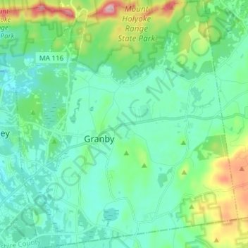
Carte topographique Granby
Carte interactive
Cliquez sur la carte pour afficher l’altitude.
À propos de cette carte
Nom : Carte topographique Granby, altitude, relief.
Altitude moyenne : 109 m
Altitude minimum : 50 m
Altitude maximum : 320 m
Autres cartes topographiques
Cliquez sur une carte pour visualiser sa topographie, son altitude et son relief.
Amherst
United States > Massachusetts > Hampshire County
Amherst, Hampshire County, Massachusetts, United States
Altitude moyenne : 100 m
Southampton
United States > Massachusetts > Hampshire County
Southampton, Hampshire County, Massachusetts, United States
Altitude moyenne : 131 m
Westbrook
United States > Massachusetts > Hampshire County > Hatfield
Westbrook, Hatfield, Hampshire County, Massachusetts, 01066, United States
Altitude moyenne : 73 m
Mill River
United States > Massachusetts > Hampshire County > Northampton
Mill River, Northampton, Hampshire County, Massachusetts, United States
Altitude moyenne : 103 m
Quabbin Park
United States > Massachusetts > Hampshire County > Ware
Quabbin Park, Administration Road, Ware, Hampshire County, Massachusetts, United States
Altitude moyenne : 181 m
Worthington
United States > Massachusetts > Hampshire County
Worthington, Hampshire County, Massachusetts, United States
Altitude moyenne : 411 m
West Ware
United States > Massachusetts > Hampshire County > Ware
West Ware, Ware, Hampshire County, Massachusetts, United States
Altitude moyenne : 162 m
Worthington Corners
United States > Massachusetts > Hampshire County > Worthington
Worthington Corners, Worthington, Hampshire County, Massachusetts, United States
Altitude moyenne : 450 m
Belchertown
United States > Massachusetts > Hampshire County
Belchertown, Hampshire County, Massachusetts, 01007, United States
Altitude moyenne : 150 m
Easthampton
United States > Massachusetts > Hampshire County
Easthampton, Hampshire County, Massachusetts, United States
Altitude moyenne : 83 m
Westhampton
United States > Massachusetts > Hampshire County
Westhampton, Hampshire County, Massachusetts, 01027, United States
Altitude moyenne : 260 m
Hatfield
United States > Massachusetts > Hampshire County
Hatfield, Hampshire County, Massachusetts, United States
Altitude moyenne : 62 m
Florence
United States > Massachusetts > Hampshire County > Northampton
Florence, Northampton, Hampshire County, Massachusetts, 01062, United States
Altitude moyenne : 78 m
Cummington
United States > Massachusetts > Hampshire County
Cummington, Hampshire County, Massachusetts, 01026, United States
Altitude moyenne : 435 m
Williamsburg
United States > Massachusetts > Hampshire County
Williamsburg, Hampshire County, Massachusetts, United States
Altitude moyenne : 280 m
South Hadley
United States > Massachusetts > Hampshire County > South Hadley
South Hadley, Hampshire County, Massachusetts, 01075, United States
Altitude moyenne : 84 m
Cushman
United States > Massachusetts > Hampshire County > Amherst > Cushman
Cushman, Amherst, Hampshire County, Massachusetts, 01003, United States
Altitude moyenne : 103 m
Piper Farm
United States > Massachusetts > Hampshire County > Belchertown
Piper Farm, Belchertown, Hampshire County, Massachusetts, United States
Altitude moyenne : 150 m
Plainfield
United States > Massachusetts > Hampshire County
Plainfield, Hampshire County, Massachusetts, 01070, United States
Altitude moyenne : 484 m
Thermopylae
United States > Massachusetts > Hampshire County > South Hadley
Thermopylae, South Hadley, Hampshire County, Massachusetts, 01061, United States
Altitude moyenne : 76 m
Northampton
United States > Massachusetts > Hampshire County
Northampton, Hampshire County, Massachusetts, United States
Altitude moyenne : 71 m