
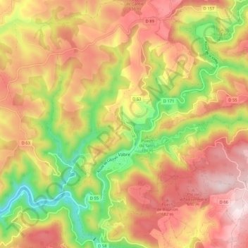
Carte topographique Vabre
Carte interactive
Cliquez sur la carte pour afficher l’altitude.
À propos de cette carte
Nom : Carte topographique Vabre, altitude, relief.
Altitude moyenne : 536 m
Altitude minimum : 259 m
Altitude maximum : 766 m
Autres cartes topographiques
Cliquez sur une carte pour visualiser sa topographie, son altitude et son relief.
Lagarrigue
Lagarrigue, Castres, Tarn, Occitania, Metropolitan France, 81090, France
Altitude moyenne : 213 m
Saint-Sulpice-la-Pointe
Saint-Sulpice-la-Pointe, Castres, Tarn, Occitania, Metropolitan France, 81370, France
Altitude moyenne : 138 m
Pampelonne
Pampelonne, Albi, Tarn, Occitania, Metropolitan France, 81190, France
Altitude moyenne : 398 m
Lescure-d'Albigeois
Lescure-d'Albigeois, Albi, Tarn, Occitania, Metropolitan France, 81380, France
Altitude moyenne : 200 m
Las Planes
France > Occitania > Tarn > Senouillac > Las Planes
Las Planes, Senouillac, Albi, Tarn, Occitania, Metropolitan France, 81600, France
Altitude moyenne : 192 m
Le Vintrou
France > Occitania > Tarn > Le Vintrou
Le Vintrou, Castres, Tarn, Occitania, Metropolitan France, 81240, France
Altitude moyenne : 610 m
Cambon-lès-Lavaur
Cambon-lès-Lavaur, Castres, Tarn, Occitania, Metropolitan France, 81470, France
Altitude moyenne : 230 m