
Faire un don
Équipez-vous pour votre prochaine aventure :
En tant que Partenaire Amazon, ce site perçoit une commission sur les achats éligibles sans surcoût pour vous.
Carte topographique Texas Creek
Cliquez sur la carte pour afficher l’altitude.
Faire un don
Équipez-vous pour votre prochaine aventure :
En tant que Partenaire Amazon, ce site perçoit une commission sur les achats éligibles sans surcoût pour vous.
À propos de cette carte
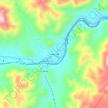
Nom : Carte topographique Texas Creek, altitude, relief.
Altitude moyenne : 2.039 m
Altitude minimum : 1.863 m
Altitude maximum : 2.349 m
Faire un don
Équipez-vous pour votre prochaine aventure :
En tant que Partenaire Amazon, ce site perçoit une commission sur les achats éligibles sans surcoût pour vous.
Autres cartes topographiques
Cliquez sur une carte pour visualiser sa topographie, son altitude et son relief.
Cañon City
United States > Colorado > Fremont County
Cañon City is located in eastern Fremont County at 38°26′48″N 105°13′42″W / 38.44667°N 105.22833°W / 38.44667; -105.22833 (38.446800, -105.228305) at an altitude of 5,332 feet (1,625 m). It sits primarily on the north side of the Arkansas River, just east of where the river exits from…
Altitude moyenne : 1.723 m
Faire un don
Équipez-vous pour votre prochaine aventure :
En tant que Partenaire Amazon, ce site perçoit une commission sur les achats éligibles sans surcoût pour vous.
Cañon City
United States > Colorado > Fremont County
The city's nickname, "the Climate Capital of Colorado", derives from the combination of unique geography and 5,300-foot (1,600 m) elevation protecting the city from harsh weather conditions. The average daily high temperature in January is 14 °F (7.8 °C) warmer in Cañon City than in Grand Junction, even…
Altitude moyenne : 1.750 m
Faire un don
Équipez-vous pour votre prochaine aventure :
En tant que Partenaire Amazon, ce site perçoit une commission sur les achats éligibles sans surcoût pour vous.