
Carte topographique Biel/Bienne
Carte interactive
Cliquez sur la carte pour afficher l’altitude.
À propos de cette carte
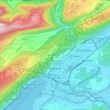
Nom : Carte topographique Biel/Bienne, altitude, relief.
Altitude moyenne : 655 m
Altitude minimum : 423 m
Altitude maximum : 1.282 m
One funicular railways leads to the national sports center of Magglingen/Macolin on the 500 metres (1,600 ft) higher Jura mountain in the west, and the other, the Bienne-Evilard Funicular, to the city hospital and to neighbouring municipality Evilard to northwest, both above the town on the eastern range of the Jura Mountains. The high, flat pastures and wood of Magglingen/Macolin span about 7 kilometres (4.3 mi) from northeast to southwest at an altitude between 800 and 1,031 metres (2,625 and 3,383 ft). The Magglingen/Macolin Funicular often leads to sunshine while Biel/Bienne is covered by low hanging clouds.
Autres cartes topographiques
Cliquez sur une carte pour visualiser sa topographie, son altitude et son relief.
Meinisberg
Switzerland > Bern > Biel/Bienne administrative district
Meinisberg, Biel/Bienne administrative district, Seeland administrative region, Bern, 2554, Switzerland
Altitude moyenne : 455 m