
Carte topographique Gowari
Carte interactive
Cliquez sur la carte pour afficher l’altitude.
À propos de cette carte
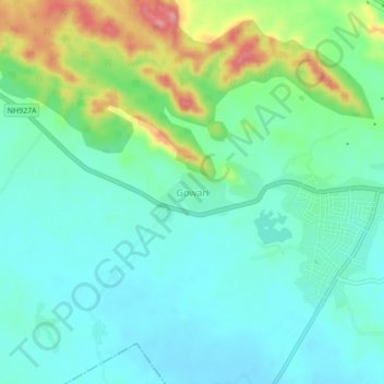
Nom : Carte topographique Gowari, altitude, relief.
Lieu : Gowari, Sagwara Tehsil, Dungarpur District, Rajasthan, India (23.64418 73.97017 23.68418 74.01017)
Altitude moyenne : 178 m
Altitude minimum : 144 m
Altitude maximum : 271 m
Autres cartes topographiques
Cliquez sur une carte pour visualiser sa topographie, son altitude et son relief.
Sagwara
India > Rajasthan > Sagwara Tehsil
Sagwara, Sagwara Tehsil, Dungarpur District, Rajasthan, 314025, India
Altitude moyenne : 177 m
Kariyana
India > Rajasthan > Sagwara Tehsil
Kariyana, Sagwara Tehsil, Dungarpur District, Rajasthan, 314032, India
Altitude moyenne : 167 m
Mandav
India > Rajasthan > Sagwara Tehsil
Mandav, Sagwara Tehsil, Dungarpur District, Rajasthan, 314024, India
Altitude moyenne : 238 m
Bheeloora
India > Rajasthan > Sagwara Tehsil > Bheeloora
Bheeloora, Sagwara Tehsil, Dungarpur, Rajasthan, 314031, India
Altitude moyenne : 144 m