
Faire un don
Équipez-vous pour votre prochaine aventure :
En tant que Partenaire Amazon, ce site perçoit une commission sur les achats éligibles sans surcoût pour vous.
Carte topographique Krasnoyarsk Krai
Cliquez sur la carte pour afficher l’altitude.
Faire un don
Équipez-vous pour votre prochaine aventure :
En tant que Partenaire Amazon, ce site perçoit une commission sur les achats éligibles sans surcoût pour vous.
Krasnoyarsk Krai
The average temperature in January is −36 °C (−32.8 °F) in the north and −18 °C (−0.4 °F) in the south. The average temperature in July is 5 to 10 °C (41 to 50 °F) in the north – where the most poleward tree line in the world is found at Ary-Mas – and +20 °C (68 °F) in the south. The annual precipitation is 316 millimeters (12.4 in) (up to 1,200 millimeters (47 in) in the foothills of the Sayan Mountains). Snow covers the central regions of the krai from early November until late March. The peaks of the Sayan Mountains higher than 2,400–2,600 metres (7,900–8,500 ft) and those of the Putorana Plateau higher than 1,000–1,300 metres (3,300–4,300 ft) are covered with permanent snow. Permafrost is absent at low altitudes south of Lesosibirsk, but as one moves north it grades from sporadic around the 58th parallel to extensive discontinuous around the 60th parallel and continuous north of the 63rd parallel.
Faire un don
Équipez-vous pour votre prochaine aventure :
En tant que Partenaire Amazon, ce site perçoit une commission sur les achats éligibles sans surcoût pour vous.
À propos de cette carte
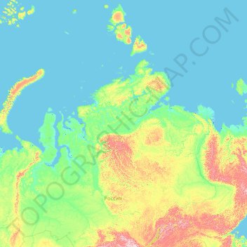
Nom : Carte topographique Krasnoyarsk Krai, altitude, relief.
Lieu : Krasnoyarsk Krai, Siberian Federal District, Russia (51.77226 74.98685 81.47418 114.73963)
Altitude moyenne : 186 m
Altitude minimum : -3 m
Altitude maximum : 2.754 m
Faire un don
Équipez-vous pour votre prochaine aventure :
En tant que Partenaire Amazon, ce site perçoit une commission sur les achats éligibles sans surcoût pour vous.
Autres cartes topographiques
Cliquez sur une carte pour visualiser sa topographie, son altitude et son relief.
Faire un don
Équipez-vous pour votre prochaine aventure :
En tant que Partenaire Amazon, ce site perçoit une commission sur les achats éligibles sans surcoût pour vous.
Faire un don
Équipez-vous pour votre prochaine aventure :
En tant que Partenaire Amazon, ce site perçoit une commission sur les achats éligibles sans surcoût pour vous.
Faire un don
Équipez-vous pour votre prochaine aventure :
En tant que Partenaire Amazon, ce site perçoit une commission sur les achats éligibles sans surcoût pour vous.
Faire un don
Équipez-vous pour votre prochaine aventure :
En tant que Partenaire Amazon, ce site perçoit une commission sur les achats éligibles sans surcoût pour vous.
Novoromanovka
Russia > Republic of Dagestan > Tarumovsky District > Novoromanovka
Altitude moyenne : -8 m
Faire un don
Équipez-vous pour votre prochaine aventure :
En tant que Partenaire Amazon, ce site perçoit une commission sur les achats éligibles sans surcoût pour vous.
Faire un don
Équipez-vous pour votre prochaine aventure :
En tant que Partenaire Amazon, ce site perçoit une commission sur les achats éligibles sans surcoût pour vous.