
Carte topographique Kentwood
Carte interactive
Cliquez sur la carte pour afficher l’altitude.
À propos de cette carte
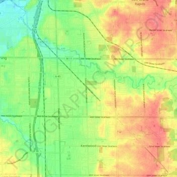
Nom : Carte topographique Kentwood, altitude, relief.
Lieu : Kentwood, Kent County, Michigan, United States (42.85449 -85.66486 42.94119 -85.54464)
Altitude moyenne : 216 m
Altitude minimum : 184 m
Altitude maximum : 248 m
Autres cartes topographiques
Cliquez sur une carte pour visualiser sa topographie, son altitude et son relief.
Richmond Park
United States > Michigan > Kent County > Grand Rapids
Richmond Park, Grand Rapids, Kent County, Michigan, United States
Altitude moyenne : 202 m
Grand Rapids
United States > Michigan > Kent County
Grand Rapids, Kent County, Michigan, United States
Altitude moyenne : 216 m
Kent City
United States > Michigan > Kent County
Kent City, Tyrone Township, Kent County, Michigan, United States
Altitude moyenne : 251 m
Sand Lake
United States > Michigan > Kent County
Sand Lake, Nelson Township, Kent County, Michigan, United States
Altitude moyenne : 277 m
Cascade Charter Township
United States > Michigan > Kent County
Cascade Charter Township, Kent County, Michigan, 49546, United States
Altitude moyenne : 229 m
Comstock Park
United States > Michigan > Kent County > Plainfield Charter Township
Comstock Park, Plainfield Charter Township, Kent County, Michigan, United States
Altitude moyenne : 206 m
Byron Township
United States > Michigan > Kent County
Byron Township, Kent County, Michigan, United States
Altitude moyenne : 221 m
Creekside Park
United States > Michigan > Kent County > Lowell
Creekside Park, Lowell, Kent County, Michigan, 49331, United States
Altitude moyenne : 201 m
Sparta
United States > Michigan > Kent County
Sparta, Sparta Township, Kent County, Michigan, United States
Altitude moyenne : 235 m
Rockford
United States > Michigan > Kent County
Rockford, Kent County, Michigan, 49351, United States
Altitude moyenne : 239 m
Cedar Springs
United States > Michigan > Kent County
Cedar Springs, Kent County, Michigan, 49319, United States
Altitude moyenne : 262 m
Sparta Township
United States > Michigan > Kent County
Sparta Township, Kent County, Michigan, 49345, United States
Altitude moyenne : 246 m
Lowell
United States > Michigan > Kent County
Lowell, Kent County, Michigan, United States
Altitude moyenne : 206 m