
Carte topographique Hokonui Hills
Carte interactive
Cliquez sur la carte pour afficher l’altitude.
À propos de cette carte
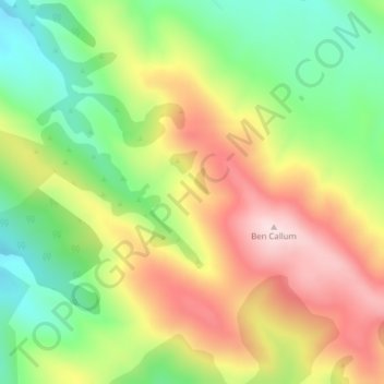
Nom : Carte topographique Hokonui Hills, altitude, relief.
Lieu : Hokonui Hills, Invercargill, Southland, New Zealand (-45.94487 168.50515 -45.94477 168.50525)
Altitude moyenne : 451 m
Altitude minimum : 281 m
Altitude maximum : 643 m
Autres cartes topographiques
Cliquez sur une carte pour visualiser sa topographie, son altitude et son relief.
Taramoa
New Zealand > Invercargill > Taramoa
Taramoa, Invercargill, Southland, New Zealand
Altitude moyenne : 8 m
Waitokariro Lagoon
Waitokariro Lagoon, Invercargill, Invercargill City, Southland, New Zealand
Altitude moyenne : 7 m
Ruapuke Islands
Ruapuke Islands, Invercargill, Southland, New Zealand
Altitude moyenne : 4 m
Tauatemaku Lagoon
Tauatemaku Lagoon, Invercargill, Invercargill City, Southland, New Zealand
Altitude moyenne : 5 m