
Faire un don
Équipez-vous pour votre prochaine aventure :
En tant que Partenaire Amazon, ce site perçoit une commission sur les achats éligibles sans surcoût pour vous.
Carte topographique Cassadaga
Cliquez sur la carte pour afficher l’altitude.
Faire un don
Équipez-vous pour votre prochaine aventure :
En tant que Partenaire Amazon, ce site perçoit une commission sur les achats éligibles sans surcoût pour vous.
À propos de cette carte
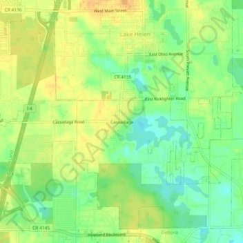
Nom : Carte topographique Cassadaga, altitude, relief.
Lieu : Cassadaga, Volusia County, Florida, 32706, United States (28.94638 -81.25589 28.98638 -81.21589)
Altitude moyenne : 20 m
Altitude minimum : 4 m
Altitude maximum : 32 m
Faire un don
Équipez-vous pour votre prochaine aventure :
En tant que Partenaire Amazon, ce site perçoit une commission sur les achats éligibles sans surcoût pour vous.
Autres cartes topographiques
Cliquez sur une carte pour visualiser sa topographie, son altitude et son relief.
DeLand
United States > Florida > Volusia County
DeLand features a varied topography characterized primarily by gentle slopes and a mix of wetlands and uplands. The city covers approximately 17.8 square miles, with about 17.6 square miles of land and a small percentage dedicated to water bodies. The elevation in DeLand is relatively modest, typically ranging…
Altitude moyenne : 20 m
Deltona
United States > Florida > Volusia County
The majority of the land in the city is of karst topography, characterized by rolling hills and an abundant amount of lakes. The St. Johns River passes through Lake Monroe, directly south of the city. The United States Geological Survey lists the city's elevation at 33 feet (10 m) above sea level at a point…
Altitude moyenne : 12 m
Faire un don
Équipez-vous pour votre prochaine aventure :
En tant que Partenaire Amazon, ce site perçoit une commission sur les achats éligibles sans surcoût pour vous.
Samsula-Spruce Creek
United States > Florida > Volusia County > New Smyrna Beach > South Village
Altitude moyenne : 8 m
Faire un don
Équipez-vous pour votre prochaine aventure :
En tant que Partenaire Amazon, ce site perçoit une commission sur les achats éligibles sans surcoût pour vous.
Faire un don
Équipez-vous pour votre prochaine aventure :
En tant que Partenaire Amazon, ce site perçoit une commission sur les achats éligibles sans surcoût pour vous.
South Daytona
United States > Florida > Volusia County
According to the United States Census Bureau, the city has a total area of 5.0 square miles (13.0 km2), of which 3.7 square miles (9.6 km2) is land and 1.3 square miles (3.4 km2) (26.29%) is water. There are nearly 44.5 miles (71.6 km) of roadway, 40 miles (64 km) of sewer lines, and 55 miles (89 km) of water…
Altitude moyenne : 4 m
Faire un don
Équipez-vous pour votre prochaine aventure :
En tant que Partenaire Amazon, ce site perçoit une commission sur les achats éligibles sans surcoût pour vous.
Deltona
United States > Florida > Volusia County
The majority of the land in the city is of karst topography, characterized by rolling hills and an abundant amount of lakes. The St. Johns River passes through Lake Monroe, directly south of the city. The United States Geological Survey lists the city's elevation at 33 feet (10 m) above sea level at a point…
Altitude moyenne : 12 m
Faire un don
Équipez-vous pour votre prochaine aventure :
En tant que Partenaire Amazon, ce site perçoit une commission sur les achats éligibles sans surcoût pour vous.
Faire un don
Équipez-vous pour votre prochaine aventure :
En tant que Partenaire Amazon, ce site perçoit une commission sur les achats éligibles sans surcoût pour vous.
Deltona
United States > Florida > Volusia County
The majority of the land in the city is of karst topography, characterized by rolling hills and an abundant amount of lakes. The St. Johns River passes through Lake Monroe, directly south of the city. The United States Geological Survey lists the city's elevation at 33 feet (10 m) above sea level at a point…
Altitude moyenne : 12 m
South Daytona
United States > Florida > Volusia County
According to the United States Census Bureau, the city has a total area of 5.0 square miles (13.0 km2), of which 3.7 square miles (9.6 km2) is land and 1.3 square miles (3.4 km2) (26.29%) is water. There are nearly 44.5 miles (71.6 km) of roadway, 40 miles (64 km) of sewer lines, and 55 miles (89 km) of water…
Altitude moyenne : 4 m
Faire un don
Équipez-vous pour votre prochaine aventure :
En tant que Partenaire Amazon, ce site perçoit une commission sur les achats éligibles sans surcoût pour vous.
Deltona
United States > Florida > Volusia County
The majority of the land in the city is of karst topography, characterized by rolling hills and an abundant amount of lakes. The St. Johns River passes through Lake Monroe, directly south of the city. The United States Geological Survey lists the city's elevation at 33 feet (10 m) above sea level at a point…
Altitude moyenne : 12 m
Faire un don
Équipez-vous pour votre prochaine aventure :
En tant que Partenaire Amazon, ce site perçoit une commission sur les achats éligibles sans surcoût pour vous.
Faire un don
Équipez-vous pour votre prochaine aventure :
En tant que Partenaire Amazon, ce site perçoit une commission sur les achats éligibles sans surcoût pour vous.
Faire un don
Équipez-vous pour votre prochaine aventure :
En tant que Partenaire Amazon, ce site perçoit une commission sur les achats éligibles sans surcoût pour vous.
Cypress Lake Park
United States > Florida > Volusia County > Cypress Lake Estates
Altitude moyenne : 22 m
Faire un don
Équipez-vous pour votre prochaine aventure :
En tant que Partenaire Amazon, ce site perçoit une commission sur les achats éligibles sans surcoût pour vous.
Faire un don
Équipez-vous pour votre prochaine aventure :
En tant que Partenaire Amazon, ce site perçoit une commission sur les achats éligibles sans surcoût pour vous.