
Carte topographique La Bethaz
Carte interactive
Cliquez sur la carte pour afficher l’altitude.
À propos de cette carte
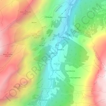
Nom : Carte topographique La Bethaz, altitude, relief.
Lieu : La Bethaz, Planté, Valgrisenche, Valle d'Aosta, Italia (45.62448 7.04734 45.66448 7.08734)
Altitude moyenne : 2.188 m
Altitude minimum : 1.509 m
Altitude maximum : 3.037 m
Autres cartes topographiques
Cliquez sur une carte pour visualiser sa topographie, son altitude et son relief.
Chez Carral
Italia > Valle d'Aosta > Planté
Chez Carral, Planté, Valgrisenche, Valle d'Aosta, Italia
Altitude moyenne : 2.206 m