
Carte topographique Cabin John
Carte interactive
Cliquez sur la carte pour afficher l’altitude.
À propos de cette carte
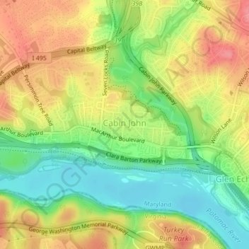
Nom : Carte topographique Cabin John, altitude, relief.
Altitude moyenne : 48 m
Altitude minimum : 7 m
Altitude maximum : 90 m
Historically, Cabin John has been part of the region known as the Potomac Gorge (Potomac Palisades), an approximately 15-mile-long (24 km) corridor or "fall zone" that sees a transition between the hard bedrock of the Piedmont to the softer rocks and soils of the Atlantic Coastal Plain and representing a drop in elevation from 140 feet (43 m) to about 10 feet (3.0 m) above sea level.
Autres cartes topographiques
Cliquez sur une carte pour visualiser sa topographie, son altitude et son relief.
Silver Spring
United States > Maryland > Montgomery County > Silver Spring
Silver Spring, Montgomery County, Maryland, United States
Altitude moyenne : 86 m
Gaithersburg
United States > Maryland > Montgomery County
Gaithersburg, Montgomery County, Maryland, United States
Altitude moyenne : 137 m
Laytonsville
United States > Maryland > Montgomery County
Laytonsville, Montgomery County, Maryland, United States
Altitude moyenne : 172 m
Montgomery Village
United States > Maryland > Montgomery County
Montgomery Village, Montgomery County, Maryland, 20886, United States
Altitude moyenne : 139 m
Damascus
United States > Maryland > Montgomery County
Damascus, Montgomery County, Maryland, 20872, United States
Altitude moyenne : 204 m
Clarksburg
United States > Maryland > Montgomery County
Clarksburg, Montgomery County, Maryland, United States
Altitude moyenne : 166 m
White Oak
United States > Maryland > Montgomery County
White Oak, Montgomery County, Maryland, 20904, United States
Altitude moyenne : 96 m
Kemp Mill
United States > Maryland > Montgomery County
Kemp Mill, Montgomery County, Maryland, 20901, United States
Altitude moyenne : 104 m
Flower Hill
United States > Maryland > Montgomery County > Redland
Flower Hill, Redland, Montgomery County, Maryland, 20879, United States
Altitude moyenne : 147 m
Fairland
United States > Maryland > Montgomery County
Fairland, Montgomery County, Maryland, United States
Altitude moyenne : 111 m
Quail Ridge
United States > Maryland > Montgomery County > Montgomery Village
Quail Ridge, Montgomery Village, Montgomery County, Maryland, 20876, United States
Altitude moyenne : 133 m
Chevy Chase Village
United States > Maryland > Montgomery County
Chevy Chase Village, Montgomery County, Maryland, United States
Altitude moyenne : 99 m
Layhill
United States > Maryland > Montgomery County
Layhill, Montgomery County, Maryland, 20906, United States
Altitude moyenne : 116 m
Glenmont
United States > Maryland > Montgomery County
Glenmont, Montgomery County, Maryland, 20902, United States
Altitude moyenne : 109 m
Redland
United States > Maryland > Montgomery County
Redland, Montgomery County, Maryland, 20855, United States
Altitude moyenne : 139 m
Cloverly
United States > Maryland > Montgomery County
Cloverly, Montgomery County, Maryland, 20905, United States
Altitude moyenne : 139 m
Dickerson
United States > Maryland > Montgomery County
Dickerson, Montgomery County, Maryland, 20842, United States
Altitude moyenne : 111 m
Glen Echo
United States > Maryland > Montgomery County
Glen Echo, Montgomery County, Maryland, 20812, United States
Altitude moyenne : 55 m
Colesville
United States > Maryland > Montgomery County
Colesville, Montgomery County, Maryland, 20904, United States
Altitude moyenne : 117 m
Aspen Hill
United States > Maryland > Montgomery County
Aspen Hill, Montgomery County, Maryland, 20906, United States
Altitude moyenne : 114 m
Colesville
United States > Maryland > Montgomery County > Colesville
Colesville, Montgomery County, Maryland, 20904, United States
Altitude moyenne : 113 m
Woodstock Equestrian Park
United States > Maryland > Montgomery County
Woodstock Equestrian Park, 20207, Montgomery County, Maryland, 20842, United States
Altitude moyenne : 124 m
Germantown
United States > Maryland > Montgomery County
Germantown, Montgomery County, Maryland, 20874, United States
Altitude moyenne : 136 m
Darnestown
United States > Maryland > Montgomery County
Darnestown, Montgomery County, Maryland, United States
Altitude moyenne : 97 m
Patuxent River State Park
United States > Maryland > Montgomery County
Patuxent River State Park, Montgomery County, Maryland, United States
Altitude moyenne : 169 m
Deerfield
United States > Maryland > Montgomery County > Potomac
Deerfield, Potomac, Montgomery County, Maryland, 20817, United States
Altitude moyenne : 84 m
South Kensington
United States > Maryland > Montgomery County
South Kensington, Montgomery County, Maryland, United States
Altitude moyenne : 92 m
Kemp Mill Estates
United States > Maryland > Montgomery County > Kemp Mill
Kemp Mill Estates, Kemp Mill, Montgomery County, Maryland, 20902, United States
Altitude moyenne : 107 m
Farmlands
United States > Maryland > Montgomery County > Travilah
Farmlands, Travilah, Montgomery County, Maryland, United States
Altitude moyenne : 93 m
Damascus
United States > Maryland > Montgomery County > Damascus
Damascus, Montgomery County, Maryland, 20872, United States
Altitude moyenne : 195 m
Germantown
United States > Maryland > Montgomery County > Germantown
Germantown, Montgomery County, Maryland, United States
Altitude moyenne : 130 m
Chevy Chase View
United States > Maryland > Montgomery County
Chevy Chase View, Montgomery County, Maryland, United States
Altitude moyenne : 82 m
Garrett Park
United States > Maryland > Montgomery County
Garrett Park, Montgomery County, Maryland, 20896, United States
Altitude moyenne : 90 m
North Potomac
United States > Maryland > Montgomery County
North Potomac, Montgomery County, Maryland, United States
Altitude moyenne : 116 m
Hunting Hill
United States > Maryland > Montgomery County > Rockville
Hunting Hill, Rockville, Montgomery County, Maryland, 20850, United States
Altitude moyenne : 127 m
Olney
United States > Maryland > Montgomery County
Olney, Montgomery County, Maryland, United States
Altitude moyenne : 136 m
Chevy Chase
United States > Maryland > Montgomery County
Chevy Chase, Montgomery County, Maryland, 20815, United States
Altitude moyenne : 99 m
Lake Needwood
United States > Maryland > Montgomery County > Redland > Avery
Lake Needwood, Avery, Redland, Montgomery County, Maryland, United States
Altitude moyenne : 122 m
Norbeck
United States > Maryland > Montgomery County > Olney
Norbeck, Olney, Montgomery County, Maryland, 20853, United States
Altitude moyenne : 134 m
Bethesda
United States > Maryland > Montgomery County
Bethesda, Montgomery County, Maryland, United States
Altitude moyenne : 81 m
Seneca
United States > Maryland > Montgomery County > Darnestown
Seneca, Darnestown, Montgomery County, Maryland, United States
Altitude moyenne : 82 m
White Oak
United States > Maryland > Montgomery County > White Oak
White Oak, Montgomery County, Maryland, 20993, United States
Altitude moyenne : 101 m
Rockville
United States > Maryland > Montgomery County
Rockville, Montgomery County, Maryland, United States
Altitude moyenne : 122 m
Great Falls
United States > Maryland > Montgomery County > Potomac
Great Falls, Potomac, Montgomery County, Maryland, United States
Altitude moyenne : 73 m
Orchard Place
United States > Maryland > Montgomery County > Gaithersburg
Orchard Place, Gaithersburg, Montgomery County, Maryland, 20899, United States
Altitude moyenne : 128 m
Washington Grove
United States > Maryland > Montgomery County
Washington Grove, Montgomery County, Maryland, 20880, United States
Altitude moyenne : 150 m
Sandy Spring
United States > Maryland > Montgomery County
Sandy Spring, Montgomery County, Maryland, 20860, United States
Altitude moyenne : 137 m
Campbell Corner
United States > Maryland > Montgomery County > Potomac
Campbell Corner, Potomac, Montgomery County, Maryland, 20818, United States
Altitude moyenne : 82 m
Derwood
United States > Maryland > Montgomery County
Derwood, Montgomery County, Maryland, 20855, United States
Altitude moyenne : 133 m
Montgomery Village
United States > Maryland > Montgomery County > Montgomery Village
Montgomery Village, Montgomery County, Maryland, 20886, United States
Altitude moyenne : 132 m