
Carte topographique Tylorstown
Carte interactive
Cliquez sur la carte pour afficher l’altitude.
À propos de cette carte
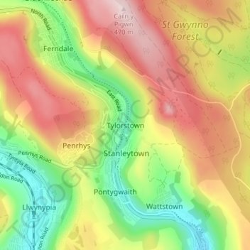
Nom : Carte topographique Tylorstown, altitude, relief.
Lieu : Tylorstown, Rhondda Cynon Taf, Wales, CF43 3HN, United Kingdom (51.62814 -3.44968 51.66814 -3.40968)
Altitude moyenne : 293 m
Altitude minimum : 118 m
Altitude maximum : 473 m
Autres cartes topographiques
Cliquez sur une carte pour visualiser sa topographie, son altitude et son relief.
Cwm Parc
United Kingdom > Wales > Rhondda Cynon Taf
Cwm Parc, Rhondda Cynon Taf, Wales, CF42 6LY, United Kingdom
Altitude moyenne : 309 m