
Carte topographique Kenilworth
Carte interactive
Cliquez sur la carte pour afficher l’altitude.
À propos de cette carte
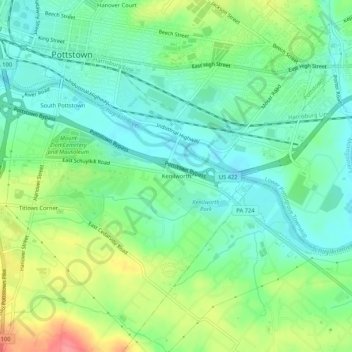
Nom : Carte topographique Kenilworth, altitude, relief.
Altitude moyenne : 61 m
Altitude minimum : 34 m
Altitude maximum : 115 m
Autres cartes topographiques
Cliquez sur une carte pour visualiser sa topographie, son altitude et son relief.
Pottstown Landing
United States > Pennsylvania > Chester County > North Coventry Township
Pottstown Landing, North Coventry Township, Chester County, Pennsylvania, 19465, United States
Altitude moyenne : 66 m
Cedarville
United States > Pennsylvania > Chester County > North Coventry Township
Cedarville, North Coventry Township, Chester County, Pennsylvania, 19465, United States
Altitude moyenne : 82 m
South Pottstown
United States > Pennsylvania > Chester County > North Coventry Township
South Pottstown, North Coventry Township, Chester County, Pennsylvania, 19465, United States
Altitude moyenne : 61 m
North Coventry Township
United States > Pennsylvania > Chester County > North Coventry Township
North Coventry Township, Chester County, Pennsylvania, 19465, United States
Altitude moyenne : 108 m