
Faire un don
Équipez-vous pour votre prochaine aventure :
En tant que Partenaire Amazon, ce site perçoit une commission sur les achats éligibles sans surcoût pour vous.
Carte topographique Almoster
Cliquez sur la carte pour afficher l’altitude.
Faire un don
Équipez-vous pour votre prochaine aventure :
En tant que Partenaire Amazon, ce site perçoit une commission sur les achats éligibles sans surcoût pour vous.
Almoster
Its climate is dry Mediterranean, with low rainfall in the summer and occasionally heavy rainfall in spring and autumn. The driest month is July, with an average rainfall of only 15 mm, and September is usually the wettest, with an average of about 75 mm. The average annual precipitation barely reaches 500 mm. The most mountainous part of the township has a continental Mediterranean climate and more rain as there is a small thermal contrast with the more southerly and lower elevation. The average temperature of the warmest month, August, is about 24 º and the coldest month, January, is about -2 to 00.
Faire un don
Équipez-vous pour votre prochaine aventure :
En tant que Partenaire Amazon, ce site perçoit une commission sur les achats éligibles sans surcoût pour vous.
À propos de cette carte
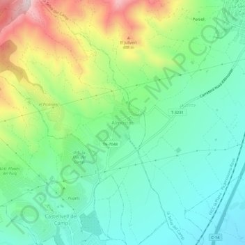
Nom : Carte topographique Almoster, altitude, relief.
Lieu : Almoster, Baix Camp, Tarragona, Catalonia, 43393, Spain (41.17606 1.09114 41.21606 1.13114)
Altitude moyenne : 289 m
Altitude minimum : 139 m
Altitude maximum : 613 m
Faire un don
Équipez-vous pour votre prochaine aventure :
En tant que Partenaire Amazon, ce site perçoit une commission sur les achats éligibles sans surcoût pour vous.