
Faire un don
Équipez-vous pour votre prochaine aventure :
En tant que Partenaire Amazon, ce site perçoit une commission sur les achats éligibles sans surcoût pour vous.
Carte topographique White Top
Cliquez sur la carte pour afficher l’altitude.
Faire un don
Équipez-vous pour votre prochaine aventure :
En tant que Partenaire Amazon, ce site perçoit une commission sur les achats éligibles sans surcoût pour vous.
White Top
White Top is a knob and spur of Cheat Mountain in southeastern Randolph County, West Virginia, USA. Sitting at an elevation of 4,085 feet (1,245 m), it is located just west of the Shavers Fork of Cheat River and Cheat Bridge. While White Top was originally crossed by the Staunton–Parkersburg Turnpike, modern-day U.S. Route 250 skirts the base of the knob beside Shavers Fork to the north and east.
Faire un don
Équipez-vous pour votre prochaine aventure :
En tant que Partenaire Amazon, ce site perçoit une commission sur les achats éligibles sans surcoût pour vous.
À propos de cette carte
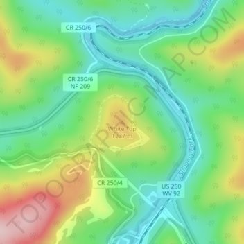
Nom : Carte topographique White Top, altitude, relief.
Lieu : White Top, Randolph County, West Virginia, United States (38.62451 -79.87678 38.62461 -79.87668)
Altitude moyenne : 1.159 m
Altitude minimum : 1.072 m
Altitude maximum : 1.318 m
Faire un don
Équipez-vous pour votre prochaine aventure :
En tant que Partenaire Amazon, ce site perçoit une commission sur les achats éligibles sans surcoût pour vous.
Autres cartes topographiques
Cliquez sur une carte pour visualiser sa topographie, son altitude et son relief.
Elkins
United States > West Virginia > Randolph County
Elkins is located at the confluence of the Tygart Valley River and Leading Creek. The average elevation is 2,000 feet (610 m) above sea level. According to the United States Census Bureau, the city has a total area of 3.43 square miles (8.88 km2), all land. Elkins is headquarters for the Monongahela National…
Altitude moyenne : 637 m
Faire un don
Équipez-vous pour votre prochaine aventure :
En tant que Partenaire Amazon, ce site perçoit une commission sur les achats éligibles sans surcoût pour vous.
Spruce Knob Lake
United States > West Virginia > Randolph County
Spruce Knob Lake is a 23-acre (0.093 km2) reservoir located within the Monongahela National Forest in Randolph County, West Virginia, USA. The recreation area surrounding Spruce Knob Lake contains camping and picnicking facilities as well as a boating site. At an elevation of 3,840 feet, it is the highest lake…
Altitude moyenne : 1.204 m
Elkins
United States > West Virginia > Randolph County
Elkins is located at the confluence of the Tygart Valley River and Leading Creek. The average elevation is 2,000 feet (610 m) above sea level. According to the United States Census Bureau, the city has a total area of 3.43 square miles (8.88 km2), all land. Elkins is headquarters for the Monongahela National…
Altitude moyenne : 637 m
Faire un don
Équipez-vous pour votre prochaine aventure :
En tant que Partenaire Amazon, ce site perçoit une commission sur les achats éligibles sans surcoût pour vous.