
Faire un don
Équipez-vous pour votre prochaine aventure :
En tant que Partenaire Amazon, ce site perçoit une commission sur les achats éligibles sans surcoût pour vous.
Carte topographique Burlington
Cliquez sur la carte pour afficher l’altitude.
Faire un don
Équipez-vous pour votre prochaine aventure :
En tant que Partenaire Amazon, ce site perçoit une commission sur les achats éligibles sans surcoût pour vous.
Burlington
Burlington hosts the Snake Alley Criterium, one of the most physically challenging races in the Midwest. The annual event is held on a 15-block course, with differences in elevation from 555 feet to 678 feet. The course is entirely on city streets, mostly in the downtown commercial area. A one-block-long climb is on the historic brick street named Snake Alley. The 276-foot-long Snake Alley has five switchbacks in a 60-foot climb. The average grade is 12.5 percent in that one block.
Faire un don
Équipez-vous pour votre prochaine aventure :
En tant que Partenaire Amazon, ce site perçoit une commission sur les achats éligibles sans surcoût pour vous.
À propos de cette carte
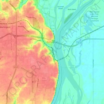
Nom : Carte topographique Burlington, altitude, relief.
Lieu : Burlington, Des Moines County, Iowa, 52601, United States (40.76095 -91.18026 40.84766 -91.07854)
Altitude moyenne : 183 m
Altitude minimum : 154 m
Altitude maximum : 219 m
Faire un don
Équipez-vous pour votre prochaine aventure :
En tant que Partenaire Amazon, ce site perçoit une commission sur les achats éligibles sans surcoût pour vous.