
Carte topographique Wildhorn
Carte interactive
Cliquez sur la carte pour afficher l’altitude.
À propos de cette carte
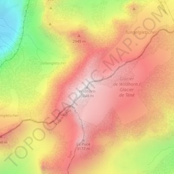
Nom : Carte topographique Wildhorn, altitude, relief.
Lieu : Wildhorn, Ayent, Hérens, Wallis, 1966, Switzerland (46.35588 7.36217 46.35598 7.36227)
Altitude moyenne : 2.768 m
Altitude minimum : 2.068 m
Altitude maximum : 3.225 m
Autres cartes topographiques
Cliquez sur une carte pour visualiser sa topographie, son altitude et son relief.
Lac de Tseuzier
Switzerland > Wallis > Hérens > Ayent
Lac de Tseuzier, Ayent, Hérens, Wallis, 1966, Switzerland
Altitude moyenne : 1.871 m
Schnidehorn
Switzerland > Wallis > Hérens > Ayent
Schnidehorn, Ayent, Hérens, Wallis, 1966, Switzerland
Altitude moyenne : 2.566 m
Bonnefille
Switzerland > Wallis > Hérens > Ayent > Anzère
Bonnefille, Anzère, Ayent, Hérens, Wallis, 1972, Switzerland
Altitude moyenne : 1.408 m
Anzère
Switzerland > Wallis > Hérens > Ayent
Anzère, Ayent, Hérens, Wallis, 1972, Switzerland
Altitude moyenne : 1.493 m