Carte topographique Uffholtz
Carte interactive
Cliquez sur la carte pour afficher l’altitude.
À propos de cette carte
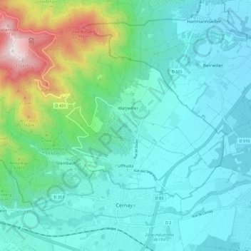
Uffholtz fait partie du canton de Cernay et de l'arrondissement de Thann-Guebwiller. Elle est une des communes qui constitue la Communauté de communes de Thann-Cernay avec Cernay (1,5 km), Steinbach et Wattwiller. Uffholtz est un départ de la route des Crêtes, la D 431, est traversée par la route des Vins d'Alsace, la D 5, la route départementale 83 (ancienne RN 83) et par un chemin balisé vers Saint-Jacques-de-Compostelle, encore à 2 180 km de là. Le village est situé à une altitude de 310 m. La commune fait partie du ressort de l'Office de tourisme de Cernay et de la région du Vieil-Armand.
Autres cartes topographiques
Cliquez sur une carte pour visualiser sa topographie, son altitude et son relief.
![Carte topographique Bourbach-le-Haut, altitude, relief](/pub/maps/relation/g9m/mfgtp/icon.jpg)
Bourbach-le-Haut
France > Grand Est > Haut-Rhin
Bourbach-le-Haut, Thann-Guebwiller, Haut-Rhin, Grand Est, France métropolitaine, 68290, France
Altitude moyenne : 701 m
![Carte topographique Mooslargue, altitude, relief](/pub/maps/relation/7zgp/dc7rr/icon.jpg)
Mooslargue
France > Grand Est > Haut-Rhin
Mooslargue, Altkirch, Haut-Rhin, Grand Est, France métropolitaine, 68580, France
Altitude moyenne : 437 m
![Carte topographique La Cave de Rodern - Schaentzel, altitude, relief](/pub/maps/node/hxtp/wv2lj3nx/icon.jpg)
La Cave de Rodern - Schaentzel
France > Grand Est > Haut-Rhin > Rodern
La Cave de Rodern - Schaentzel, Rodern, Colmar-Ribeauvillé, Haut-Rhin, Grand Est, France métropolitaine, 68590, France
Altitude moyenne : 473 m
![Carte topographique Masevaux-Niederbruck, altitude, relief](/pub/maps/relation/4551/l3k3gt/icon.jpg)
Masevaux-Niederbruck
France > Grand Est > Haut-Rhin
Masevaux-Niederbruck, Thann-Guebwiller, Haut-Rhin, Grand Est, France métropolitaine, 68290, France
Altitude moyenne : 577 m
![Carte topographique Hagenthal-le-Bas, altitude, relief](/pub/maps/relation/kwzs/49kmt/icon.jpg)
Hagenthal-le-Bas
France > Grand Est > Haut-Rhin
Hagenthal-le-Bas, Mulhouse, Haut-Rhin, Grand Est, France métropolitaine, 68220, France
Altitude moyenne : 395 m
![Carte topographique Ampfersbach, altitude, relief](/pub/maps/node/mztp/h1gvnnmt/icon.jpg)
Ampfersbach
France > Grand Est > Haut-Rhin > Stosswihr
Ampfersbach, Stosswihr, Colmar-Ribeauvillé, Haut-Rhin, Grand Est, France métropolitaine, 68140, France
Altitude moyenne : 634 m
![Carte topographique Ottmarsheim, altitude, relief](/pub/maps/relation/9414/nqs51/icon.jpg)
Ottmarsheim
France > Grand Est > Haut-Rhin
Ottmarsheim, Mulhouse, Haut-Rhin, Grand Est, France métropolitaine, 68490, France
Altitude moyenne : 224 m
![Carte topographique Steinbrunn-le-Haut, altitude, relief](/pub/maps/relation/nlm2/j2718/icon.jpg)
Steinbrunn-le-Haut
France > Grand Est > Haut-Rhin
Steinbrunn-le-Haut, Mulhouse, Haut-Rhin, Grand Est, France métropolitaine, 68440, France
Altitude moyenne : 320 m
![Carte topographique Volgelsheim, altitude, relief](/pub/maps/relation/5l3l/m17nh/icon.jpg)
Volgelsheim
France > Grand Est > Haut-Rhin
Volgelsheim, Colmar-Ribeauvillé, Haut-Rhin, Grand Est, France métropolitaine, 68600, France
Altitude moyenne : 193 m
![Carte topographique Sainte-Marie-aux-Mines, altitude, relief](/pub/maps/relation/16tj/6zh3l/icon.jpg)
Sainte-Marie-aux-Mines
France > Grand Est > Haut-Rhin > Sainte-Marie-aux-Mines
Sainte-Marie-aux-Mines, Colmar-Ribeauvillé, Haut-Rhin, Grand Est, France métropolitaine, 68160, France
Altitude moyenne : 713 m
![Carte topographique Vosges, altitude, relief](/pub/maps/node/6cmt/9dvf48b3/icon.jpg)
Vosges
France > Grand Est > Haut-Rhin > Goldbach-Altenbach
Vosges, Goldbach-Altenbach, Thann-Guebwiller, Haut-Rhin, Grand Est, France métropolitaine, 68760, France
Altitude moyenne : 864 m
![Carte topographique Lapoutroie, altitude, relief](/pub/maps/relation/knzs/492mt/icon.jpg)
Lapoutroie
France > Grand Est > Haut-Rhin
Lapoutroie, Colmar-Ribeauvillé, Haut-Rhin, Grand Est, France métropolitaine, 68650, France
Altitude moyenne : 698 m
![Carte topographique Wasserbourg, altitude, relief](/pub/maps/relation/m151/kjwg57/icon.jpg)
Wasserbourg
France > Grand Est > Haut-Rhin > Wasserbourg
Wasserbourg, Colmar-Ribeauvillé, Haut-Rhin, Grand Est, France métropolitaine, 68230, France
Altitude moyenne : 729 m
![Carte topographique Masevaux, altitude, relief](/pub/maps/relation/9gt/wqh5k/icon.jpg)
Masevaux
France > Grand Est > Haut-Rhin > Masevaux-Niederbruck
Masevaux, Masevaux-Niederbruck, Thann-Guebwiller, Haut-Rhin, Grand Est, France métropolitaine, 68290, France
Altitude moyenne : 577 m
![Carte topographique Katzenthal, altitude, relief](/pub/maps/relation/mvgp/6jfkl/icon.jpg)
Katzenthal
France > Grand Est > Haut-Rhin > Katzenthal
Katzenthal, Colmar-Ribeauvillé, Haut-Rhin, Grand Est, France métropolitaine, 68230, France
Altitude moyenne : 293 m
![Carte topographique Eschbach-au-Val, altitude, relief](/pub/maps/relation/tfm2/plk9gt/icon.jpg)
Eschbach-au-Val
France > Grand Est > Haut-Rhin > Eschbach-au-Val
Eschbach-au-Val, Colmar-Ribeauvillé, Haut-Rhin, Grand Est, France métropolitaine, 68140, France
Altitude moyenne : 630 m
![Carte topographique Storckensohn, altitude, relief](/pub/maps/relation/blkl/zt6z3q/icon.jpg)
Storckensohn
France > Grand Est > Haut-Rhin > Storckensohn
Storckensohn, Thann-Guebwiller, Haut-Rhin, Grand Est, France métropolitaine, 68470, France
Altitude moyenne : 675 m
![Carte topographique Sondernach, altitude, relief](/pub/maps/relation/hsrr/zt2l3q/icon.jpg)
Sondernach
France > Grand Est > Haut-Rhin > Sondernach
Sondernach, Colmar-Ribeauvillé, Haut-Rhin, Grand Est, France métropolitaine, 68380, France
Altitude moyenne : 931 m
![Carte topographique Ribeauvillé, altitude, relief](/pub/maps/relation/9xz4/k3mt6/icon.jpg)
Ribeauvillé
France > Grand Est > Haut-Rhin > Ribeauvillé
Ribeauvillé, Colmar-Ribeauvillé, Haut-Rhin, Grand Est, France métropolitaine, 68150, France
Altitude moyenne : 395 m
![Carte topographique Husseren-les-Châteaux, altitude, relief](/pub/maps/relation/31z4/px951/icon.jpg)
Husseren-les-Châteaux
France > Grand Est > Haut-Rhin > Husseren-les-Châteaux
Husseren-les-Châteaux, Colmar-Ribeauvillé, Haut-Rhin, Grand Est, France métropolitaine, 68420, France
Altitude moyenne : 398 m
![Carte topographique Kaysersberg, altitude, relief](/pub/maps/relation/8p1h/bvbnx/icon.jpg)
Kaysersberg
France > Grand Est > Haut-Rhin > Kaysersberg-Vignoble
Kaysersberg, Kaysersberg-Vignoble, Colmar-Ribeauvillé, Haut-Rhin, Grand Est, France métropolitaine, 68240, France
Altitude moyenne : 523 m
![Carte topographique Niedermorschwihr, altitude, relief](/pub/maps/relation/6x9m/mwxtp/icon.jpg)
Niedermorschwihr
France > Grand Est > Haut-Rhin
Niedermorschwihr, Colmar-Ribeauvillé, Haut-Rhin, Grand Est, France métropolitaine, 68230, France
Altitude moyenne : 339 m